Article
Maps as Statements of Power and Domination
Topics
Places and Buildings
1 January 2015
Drawing from his personal collection of maps amassed over three decades, Dr Farish A. Noor invites us to truly read maps and look beyond their geographical boundaries.
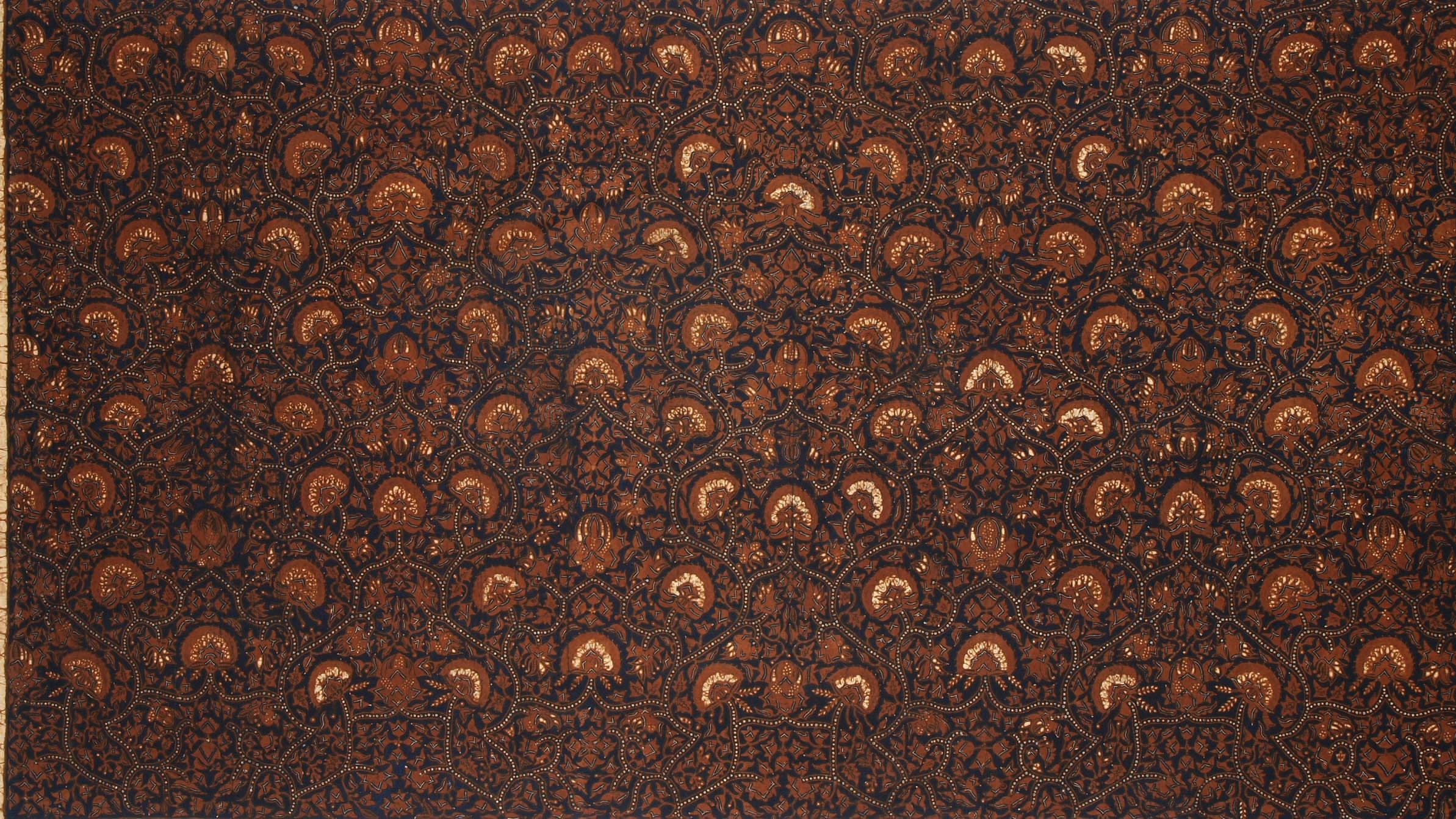
Close-up of a Central Javanese batik embellished with a cosmological map motif. Courtesy of Farish A. Noor.
“The census, the map, and the museum: together they profoundly shaped the way in which the colonial state imagined its dominion – the nature of the human beings it ruled, the geography of its domain, and the legitimacy of its ancestry.”
– Benedict Anderson, Imagined Communities
I write this as an academic who also happens to be a collector of antiquarian books, prints and maps of Southeast Asia, a hobby I have indulged in since my late teens, and which has left me in a state of perpetual poverty as a result. Those who belong to this small fraternity of aficionados will readily testify to the joy of collecting and the boundless pleasure of reading and appreciating books and maps that date back centuries. I am proud to say that although my passion has left me penniless, the state of destitution, thankfully, applies only to my wallet and not my sensibilities.
Antiquarian maps have long been sought after, for both their aesthetic as well as historical value. Those familiar with the workings of the antiquarian trade would know that such maps are also worthy investments in the long-run.
Having said that, the academic in me would also point to the academic worth of maps as documents of power and as records of the progression of power in the most comprehensive sense: both political – military as well as epistemic. Aside from the inherent beauty of some maps – and it should be noted that some antiquarian maps are undoubtedly visually stunning objects in themselves, deserving of appreciation as paintings and sculpture are – the added value of old maps is that they are historical records that document the march of exploration and conquest as well as the spread of (geographic) knowledge of the world.
Mapping and Knowledge: How We Come to Know the World
In this essay I would Like to address the topic of maps and map-making and how maps can (and should) be read rather than simply merely looked at. By reading maps I mean that the map is never simply a chart or a plan of territory, but also a statement (of intent or ambition) that can be interpreted and understood.
We need to begin with the premise that maps are never simply maps. Here is where we encounter the puzzle of maps and map making, and it is more an epistemic puzzle than a practical one. For if we were to start off with the Platonic premise that all forms of representation are merely that – re-presentations of things as they really are – then all representations are to be regarded as counterfeit. What, then, is a map? And how do maps map the world? Granted that all maps are necessarily the product of human effort and are invariably tainted by subjective bias and the cultural perspectivism of the cartographer, they nevertheless need to correspond to some reality in order to fulfil their functions as maps that, well, map. But as representations of the world, maps merely stand for the "thing" that they represent.
The philosopher Heidegger would interject by noting that the world of the thing-in-itself can never be known directly, but only through a (flawed, limited and subjective) human perspective. Taken In broad strokes, the upshot of this argument is that a map of Asia therefore does not really "discover" Asia, but really invents Asia as it goes along.1
Some might object to this argument on the grounds that maps illustrate things as they are in the world, but that misses the point: While it cannot be denied that things exist in the world, the more fundamental question is how those things come to be regarded as the things they are in the first place; which can only be a matter that is subjectively decided. For instance, elevations of earth and rock exist, but whether they exist as mountains or hills is a matter of subjective human judgement, and lie not in the things-in-themselves. There is, in fact, no universal standard that distinguishes the difference between hills and mountains, and the criteria differs from country to country. The American definition of a mountain is any land mass that rises to the height of a thousand feet (610m), while in the United Kingdom, mountains need to be higher than two thousand feet (305m). (One country's mountain is another country's hill, evidently.)
That mountains are never simply mountains and that landscapes are never simply landscapes is evident when we compare the different modes of mapping that once existed in the world, prior to the advent of modern states and modern regimes of knowledge and power. Benedict Anderson (1983) notes that prior to Western colonialism in Southeast Asia, these societies had developed and used two types of native maps that were meaningful and relevant to their own needs: The cosmological map and the travel guide-map. In Anderson's words:
"The 'cosmograph' was a formal representation of the three worlds of traditional cosmology. The cosmography was not organised horizontally, like our own maps; rather a series of superterrestrial heavens and subterrestrial hells wedged in the visible world along a single vertical axis. It was useless for any journey save that in a search for salvation and merit. The second type, wholly profane, consisted of diagrammatic guides for military campaigns and coastal shipping. Organised roughly by the quadrant, their main features were written-in notes for marching and sailing times, required because the map-makers had no technical conception of scale... Neither type of map marked borders."2
The cosmological map that Anderson speaks of was common in Southeast Asia and can be seen in the motifs of Javanese batik cloth that were produced then and even now. Patterns such as lereng, cuwiri and wahyu tumurun repeat the cosmological ordering of the Javanese universe with the heavens above and hell below, with humankind residing in the material world of objects in between. The Javanese understanding of themselves and their place in the world was complex, and apart from the cosmological worldview that placed them in the natural material world – where gods and demigods interacted with and directed the affairs of human beings – the idea of "Javaneseness" was itself fluid and amorphous.
Such maps are hardly ever seen – much less used – these days, living as we do in a modern world that has been shaped and informed by our modern world-view and sensibilities. Across the post-colonial world, schools that teach cartography and mapping do so via the medium of the terrestrial map that charts out lands and seas, delineating borders of states and marking out the territory of respective nation-states, which remain the primary actors on the stage of global politics. Living as we do in the age of such nation-states, it is no wonder that our own understanding of geography and mapping has been shaped accordingly, and that the present generation of Asians are somewhat disconnected from earlier forms of mapping that were once familiar to their ancestors. But the questions arise: How did this modern form of mapping emerge and what can be said about modern maps and how they map the world?
Maps as a History of Ideas: How Asia Came to be Known
The maps that I have been collecting for more than three decades are almost entirely European or inspired by European cartography. Among the joys alluded to the map collector mentioned earlier is having the time to look at them at leisure and to discern the evolution of knowledge and mastery of the globe over the centuries.
Beginning with some of the oldest maps in my collection such as Sebastian Münster's3 maps of Southeast Asia (1540) and Asia (1598), we can see how the world was perceived then. Münster's 1540 map of Southeast Asia was Ptolemaic4 in its inspiration, drawing from classical sources that suggested the world ended at the East and that there was no such thing as the Pacific Ocean. Among the quirks of the map are the obvious absence of Java, Borneo. Sulawesi and the rest of the archipelago,and the fact that Southeast Asia was then referred to as Greater India or India Extra Gangem. In his later map of the Asian continent (1598), Münster gives us a glimpse of Asia – rendered more accurately this time – that is entirely bereft of borders, suggesting a fluidity of movement and contact that has been alluded to by scholars like K. N. Chaudhuri whose "Asia before the age of Europe" was indeed a seamless landmass where peoples, ideas and commodities moved with ease, and which long pre-dates our much-vaulted claims of globalisation and cosmopolitanism today.
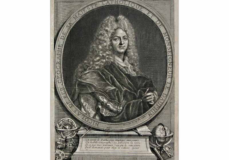
Portrait of French cartographer and geographer, Nicholas de Fer. Wikimedia Commons.
These maps, produced as they were in the 16th century, tell us something about the nations that produced them. Münster's maps (1540 and 1598) were produced at a time when Western Europe was slowly emerging from the Dark Ages and when European military-economic power was unable to conquer and dominate the rest of the world. Long before the Industrial Revolution, the first maps of Asia by the Spanish and Portuguese – and later the English, Dutch, French and other Europeans – depicted an Asia that was vast, rich and overpowering – but at the same time laden with wonders and all things exotic. (Note that Münster's 1540 map of Southeast Asia comes with curious vignettes of strange and wonderful creatures that were said to roam the countryside in Asia.)
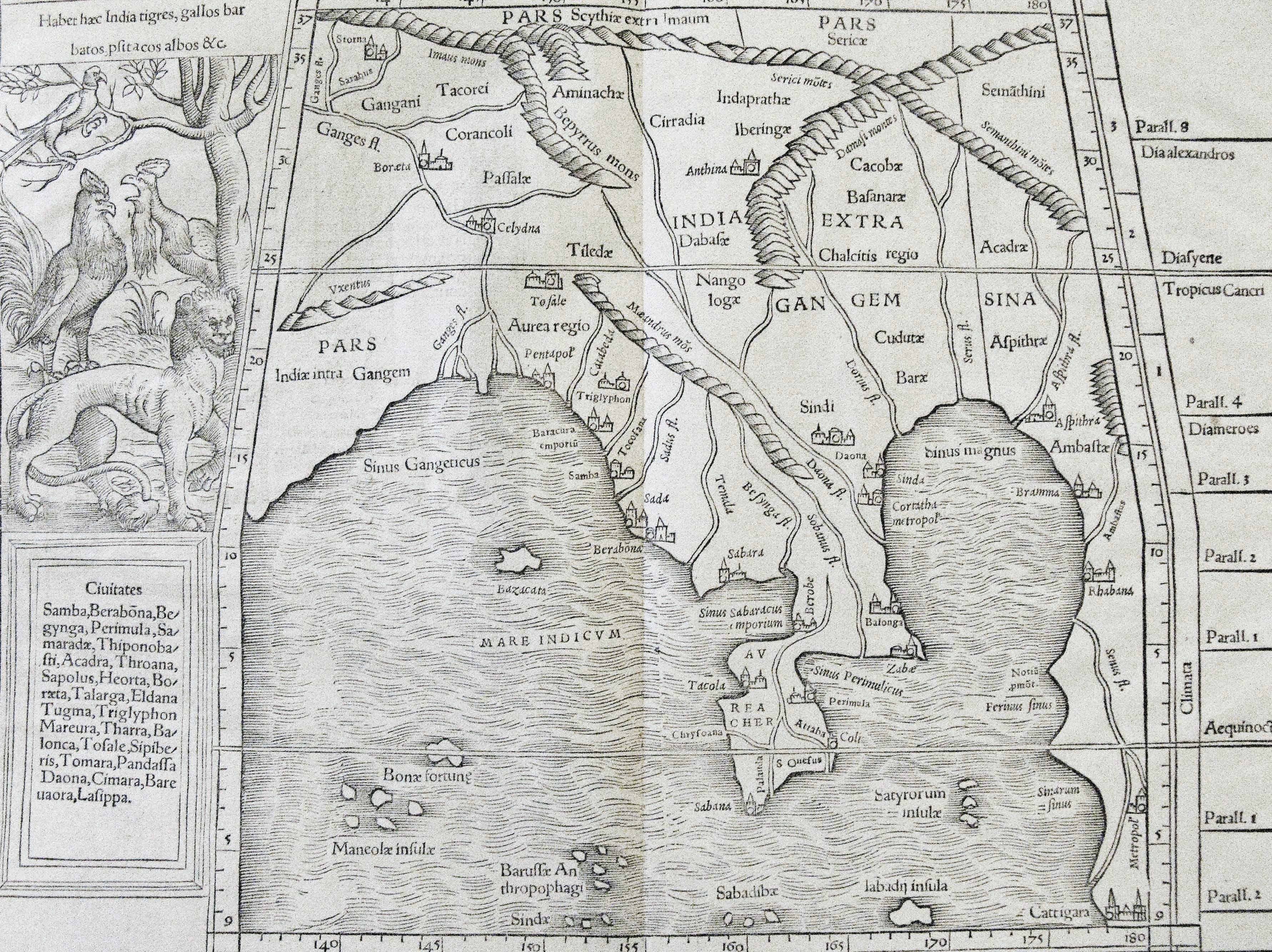
Münsters 1540 map of Southeast Asia made no reference to Java, Borneo and the rest of the archipelago, and the region was referred to as Greater India. Courtesy of Farish A. Noor.
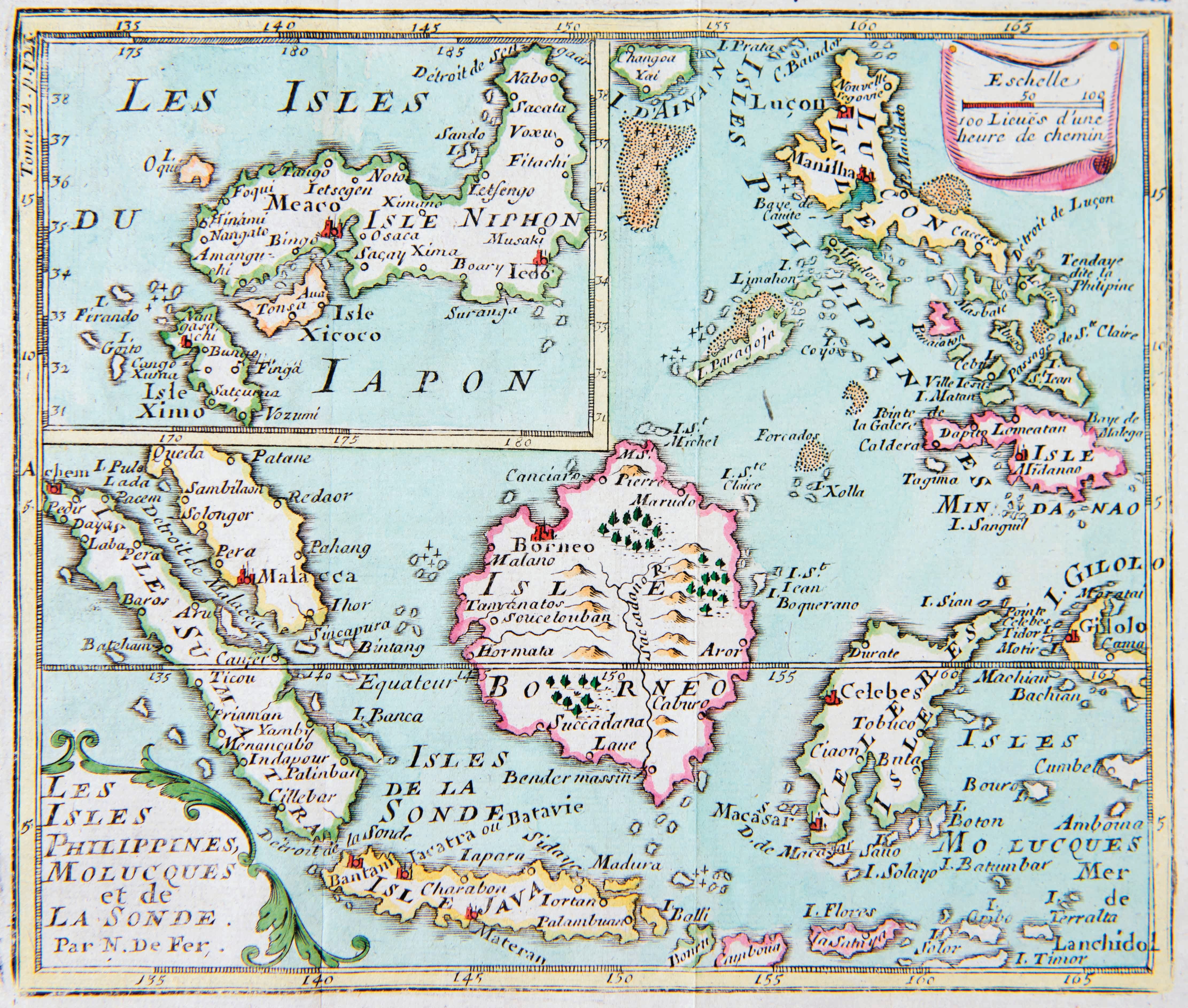
Maps of Asia grew more sophisticated and detailed over the next century as European explorers intensified their efforts to venture into the region – initially for the sake of trade and finding the precise route to the Spice Islands, and later for conquest. From the maps of Petrus Bertius5 (1661) to Nicholas de Fer6 (1714), we can actually see how the development of better maritime technology gave the Western explorers and merchants an edge over their Asian rivals, and how in time they were able to navigate their way across the archipelago and produce maps that grew increasinqly more accurate with each new navigation. Bertius' (1616) early map of Java, for instance, was for all intents and purposes completely useless as a tool for precise navigation but it does show us where the first European merchant-explorers first landed and made contact with the Javanese. The map points out the major trading centres along the northern coastline of Java, but offers no information whatsoever about the southern coast of the island, for the simple reason that few European ships had ever ventured there at that point.
Antonio Zatta e Fgli's7 1784 map of Asia reveals even more about this story of discovery and the extension of Western knowledge about the Orient in the manner in which it offers detailed and precise information about the Indian subcontinent and the Southeast Asian archipelago, but is relatively silent about China and Japan. Looking at the map today, and scanning it from West to East, we can clearly see the march of power and exploration going hand-in-hand.
By the late 18th century, much of the Indian subcontinent and Southeast Asia had been mapped out, thanks in part to the intense rivalry between the various European trading powers that wanted to set up their bases of operation there. But turning to the East we can see that much of East Asia remained vacant and obscure, thanks to the policies of the kingdoms of China and Japan (that refused to allow Europeans to penetrate deeper into the interior of their realms) and also thanks to the power that the East Asian states had (in comparison with the weaker Southeast Asian polities) that prevented further colonial intervention and cartography.
Through these maps we can see the story of Empire and colonialism unfolding – as the trading nations of Western Europe developed their military and transport capabilities, they were increasingly able to travel further and to project their power abroad. Zatta e Figli's map of Asia shows an Asia of the 18th century where Western power and knowledge were spreading in tandem from West to East, and also tells us something about how some of the Asian kingdoms then (notably China and Japan) had attempted to resist the combined might of Western economic and epistemic power. South and Southeast Asia had been "unveiled" thanks to the technological advantage enjoyed by the militarised trading companies of England, Holland, France and Spain, which conducted their business dealings in the form of armed companies that could also conquer territories in the name of their respective nations.
Maps can, therefore, be read as documents that record the rise and fall of powers, and how the process of knowing Asia was linked to the relative decline of Asian nations and their inability to resist such attempts at charting and mapping their territories. As Indian and Southeast Asian kingdoms declined in both economic and military power, so too were their territories opened up to European cartographers who began to venture further inland, producing maps that were more accurate and reliable, but which also told the story of Western conquest of the East.
Nicholas de Far's 1714 Geographie. Courtesy of Farish A. Noor.
Maps as Colonial History: Cartography in the Service of Empire
In 1817, The History of Java by Thomas Stamford Raffles was published, one year after the brief British occupation of Java came to an end. Later, in 1820, John Crawfurd's A History of the Indian Archipelago was published. While both works feature maps that were produced by the same cartographer. J. Walker, the two maps tell us two very different stories of the men who wrote the books and their perceived roles during the British occupation of the Dutch colony of the East Indies.
Crawfurd's map of the Southeast Asian archipelago featured all of the East Indies, as well as the Malayan Peninsula and the Straits Settlements. Hand-coloured versions of the map point out the British-ruled Straits Settlements and parts of the Malayan Peninsula that had come under British influence, whereas the Dutch East Indies were marked by a different coloured outline altogether. By this stage, the borderless world of Asia envisioned and captured in the map of Münster (1598) was long gone and the process of colonisation had begun in earnest, carving out chunks of Asia and appropriating pieces of land under the rule of various Western empires.
Raffles' map, however, stands out in the manner in which it singles out Java in particular, and is replete with knowledge of the land and what lay beneath its surface as well. It includes several smaller maps of coastal landing-sites (including one of Pacitan, along the southern coast of Java, which hitherto had not been properly surveyed and mapped by anyone), as well as a map of the mineral deposits of Java located across the island.
The Raffles-Walker map of 1817 marked the most significant advance in terms of knowledge of Java at the time. Not only did it obviously surpass the maps of earlier cartographers such as Langenes and Bertius, it was also superior to the map of John Stockwell (1811 and 1812) published at the outset of the British occupation of the island, as well as the maps that had been produced by the Dutch who had controlled Java since the 17th century. The Raffles- Walker map was fundamentally a statement of power and control, for it depicted not only the antiquities of Java – important Javanese temples and heritage sites such as Borobudur, Prambanan, Dieng and the temples of East Java are all accounted for in the map - but also the advance of British power across the island.
Two features stand out on this map: Across the middle of Java is a dotted line that charts the progress of Raffles himself – as he had set out to map the island and explore the interior – a journey that brought him to the ruins of Borobudur, which was mapped, drawn and hastily restored. On the western part of the map is a clear, straight line that marks the "new road" that was constructed by the British in 1815 that connected Batavia (Jakarta) to the coastal city of Cirebon, by-passing many isolated villages and towns in the countryside, and rendering the journey from Batavia to Cirebon much faster and easier.
These two features tell us something about the nature of British rule in Java and what the British colonial administrators – notably Raffles himself – wanted to do during their period of rule there. Raffles' exploratory mission sought to identify the important relics and heritage sites of Java's past, establishing their antiquity and subsequently relocating them to museums as part of local native history. The new road of 1815, on the other hand, was a marker of progress and a statement of intent: It demonstrated how the British, over a period of six years, had not only become masters of the land they surveyed, but were also able to alter that land by the creation of new roads that allowed for even deeper penetration into the interior, and in times of crisis would also be used to project and deliver British military power to other parts of Java with expedience.
The inclusion of Raffles' exploratory path and the new road of 1815 in the final version of the Raffles-Walker map was a testament of power in every sense of the word – epistemic power (in the sense that the British had managed to know more about the past of Java than the Dutch and Javanese themselves) as well as military-economic-administrative power (in the sense that all parts of the island had been brought closer together via a network of new roads, canals and paths, and implying that no part of Java would ever be obscure again.)
Such maps produced in the 19th century were, and remain, documents of imperial-colonial power. By the time men like Crawfurd and Raffles were writing about Southeast Asia and mapping the region, Western colonial power and colonial knowledge were both at their zenith, rendering local knowledge- systems and world-views redundant or at best quaint or exotic. Half-a-century earlier, cartographers such as Alexander Dalrymple (who mapped North Borneo, Sulu, Palawan and Mindanao in 1764) were still able to acknowledge local sources of information and data, and on his map of the East Borneo coast, Dalrymple even pays tribute to local Bajao and Sutu navigators who helped him in his work. It is quite telling that no such attribution was found in the works of Crawfurd, Raffles and those who came after them, for by then the British East India Company and the Dutch East India Company were staffed by Western cartographers schooled in Western norms of map-making, and who viewed the lands that they conquered as commercial prizes for possession and exploitation.
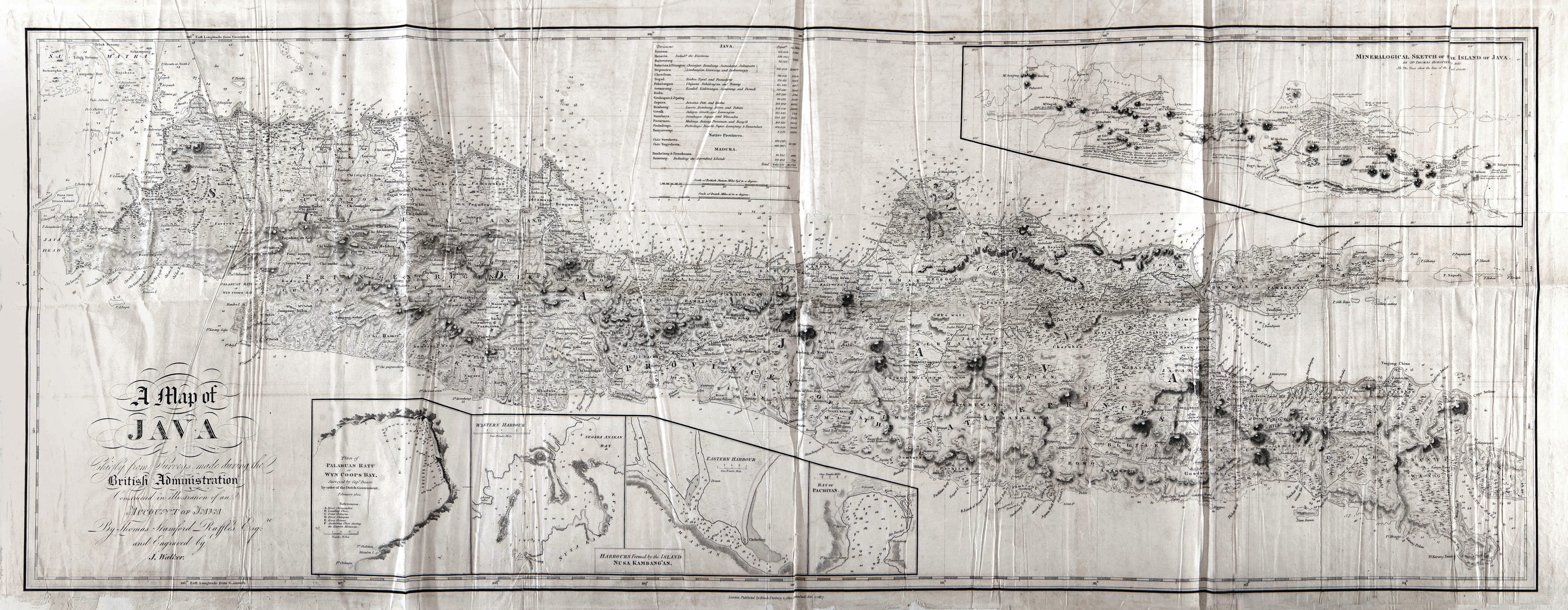
A Map of Java was produced by the British cartographer J. Walker in 1817, and appeared in the book The History of Java by Stamford Raffles. The map is notable for its documentation of the advance of British power across the island. Courtesy of Farish A. Noor.
Collecting History, Regarding Power
For map collectors with an academic disposition, antiquarian map collecting is more than a hobby with ample dividends. Beautiful though such maps may be, their added worth lie in the story they tell, which happens to be the story of power and knowledge, and how the two came together during the age of late industrial colonial-capitalism. The lesson that can be derived from maps is that the world never simply is or was, but is instead constructed via human intellectual (and martial) effort, and put together into a coherent whole that can be seen and known.
The maps of Asia I have discussed in this essay tell us something about how the idea of "Asia" came about, and how Asia was later divided into neat compartmentalised blocs comprising "Central Asia", "South Asia", "Southeast Asia" and "East Asia". From the fluid and globalised world of Münster in the 16th century to the compartmentalised one of the 20th century, maps tell us how the world was literally and figuratively made up, invented, categorised and compartmentalised. But for us to fully appreciate these developments as they have been recorded in maps, we need to go beyond simply looking at them, and begin to see what is written in them.
About the Author
Dr Farish A. Noor is an Associate Professor at the S. Rajaratnam School of International Studies (RSIS), Nanyang Technological University (NTU), Singapore. He has been collecting books, maps and prints of Asia since his student days in Europe and has been researching the subject of state-formation and religio-political movements across Asia.
References
Anderson, B. (1983). Imagined communities: Reflections on the origins and spread of nationalism. London: Verso Press. (Call no.: R 320.54 AND)
Chaudhuri, K.N. (1990). Asia before Europe: Economy and civilisation in the Indian ocean from the rise of Islam to 1750. Cambridge University Press. (Call no.: RCLOS 320.54 AND)
Crawfurd, J. (1820). History of the Indian archipelago: Containing an account of the manners, arts, languages, religions, institutions and commerce of its inhabitants. Edinburgh: A. Constable and Co. (Call no.: RRARE 915.9 CRA; Accession nos.: B29033806I [Vol. I]; & B29033809A [Vol. II])
Raffles, T.S. (1817). History of the Indian archipelago: Containing an account of the manners, arts, languages, religions, institutions and commerce of its inhabitants. London: Black, Parbury and Allen. (Call no.: RCLOS 959.82 RAF)
Endnotes
1 Anderson, B. (1983). Imagined communities: Reflections on the origins and spread of nationalism. (pp. 163–164). London: Verso Press. (Call no.: R 320.54 AND)
2 Anderson , 1983, pp. 171–172.
3 Sebastian Münster was one of the first catographers who produced an account of the world as it was then known. His work Cosmographia (1544) included some of the first maps of Asia.
4 This refers to all maps that were inspired by the geographical accounts of the scholar Claudius Ptolemy, a 2nd-century Greek astronomer and mathematician.
5 Petrus Bertius was a Flemish cartographer who was also known for his writings on philosophy and theology. His works on geography included some of the first detailed maps of Asia, with information culled from European navigators who had travelled there.
6 Nicholas de Fer was a French cartographer whose influence extended beyond France: Apart from producing maps for the King of France, he also produced maps and books on geography and navigation for the court of Spain.
7 Antonio Zatta was a Venetian cartographer whose production was enormous by any standards. He produced very detailed maps of Europe, Africa and Asia, and his masterpiece was his four-volume atlas of the world.