Article
A Portuguese Map of Sincapura
Topics
Collection Highlights
1 January 2016
Published in 1882, this map is one of the earliest to depict precolonial Singapore and indicate the various maritime channels around the island.
By Nor-Afidah Abdul Rahman
Title: Malaca, l’Inde Méridionale et le Cathay: Manuscrit Original Autographe de Godinho de Erédia, Appartenant a la Bibliothèque Royale de Bruxelles
Translated by: Léon Janssen
Year published: 1882 (based on the original 1613 Portuguese manuscript Declaracam de Malaca e India Meridional com o Cathay by Manuel Godinho de Erédia)
Publisher: Librairie Europeenne C. Muquardt (Bruxelles)
Language: Portuguese and French
Type: Book with text and maps; 292 pages
Call no.: RRARE 910.9469 GOD-[SEA]
Accession no.: B18975443H
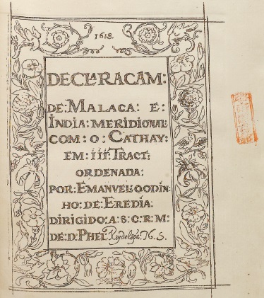
The title page of Malaca, l’Inde Méridionale et le Cathay has a floral border and bears the distinct red vertical stamp of the Syonan Library (Syonan Tosyokan) – the name the National Library was known as during the Japanese Occupation. All rights reserved, National Library Board, Singapore.
Originally drawn in 1604, Discripsao chorographica dos estreitos de Sincapura e Sabbam. ano. 1604 (Chorographic Description of the Straits of Sincapura and Sabbam 1604 A.D) is one of the earliest maps to depict precolonial Singapore, and more importantly, identifies recognisable names of places – Sunebodo (Sungei Bedok), Tanamena (Tanah Merah), Tanion Ru (Tanjong Rhu) and an island called Blacan Mati (Pulau Blakang Mati or Sentosa) – along its eastern coast.1 The map refers to the main island as Sincapura – one of several early names given to the island.
The name Xabandaria on this map west of Tanjong Rhu would have indicated the location of a Shahbandar or harbour master’s compound. Under the antecedent 15th-century Malay law code, Undang-undang Melaka, the Shahbandar or harbour master was one of the four high officials appointed by the Sultan.2 The Sultan’s Shahbandar had jurisdiction over all foreign merchants and marine vessels. About two years after this map was produced, it would be the “Sabander van Sincapura” (Harbour master of Singapore) who first met Admiral Cornelis Matelief de Jonge in 1606.3 The Shahbandar then brought the Dutch Admiral to meet Sultan Alauddin Riayat Shah III and this meeting formed the Dutch-Johor alliance against the Portuguese. Not surprisingly, Jacques Coutre, a Flemish merchant writing about his Asian sojourn in the early 1600s, called Singapore “Ysla de la Sabandaria Vieja” or “Island of the Old Shahbandaria”.4
This map – which is part of a manuscript entitled Declaracam de Malaca e India Meridional com o Cathay – is also important because it is one of the earliest to indicate the various maritime channels around Singapore. The Old Strait of Singapore (Estreito Velho) is shown on this map running close to Sincapura island while the New Strait (Estreito Nouo) runs further south. The Old Strait is the waterway that early European mariners used prior to the mid-1700s. Later European maps, however, marked the Old Strait of Singapore as the waterway separating Johor from Singapore Island, which today is called the or Johor Strait.
The details in the map suggests that the cartographer, Manuel Godinho de Erédia (1563–1623), was familiar with the region. This map was included in his manuscript written in Portuguese in 1613 and is presently in the collection of the Bibliothèque Royale in Brussels.
In 1882, Léon Janssen published a facsimile of this Portuguese manuscript, including all the maps and following that, at the end of the book, the translated French text. He then gave it a French title Malaca, l’Inde Méridionale et le Cathay: Manuscrit Original Autographe de Godinho de Erédia. The map shown here comes from a copy of this 1882 fascimile edition in the National Library’s collection.
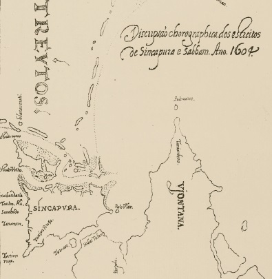
Originally drawn in 1604, Discripsao Chorographica dos Estreitos de Sincapura e Sabbam. ano. 1604 (Chorographic Description of the Straits of Sincapura and Sabbam 1604 A.D.) is one of the earliest maps to depict the coastal areas of precolonial Singapore with names that are still recognisable today. All rights reserved, Janssen, L. (Trans.) (1882). Malaca, I’Inde Méridionale et le Cathay: Manuscrit Original Autographe de Godinho de Erédia, Appartenant a la Bibliothèque Royale de Bruxelles. Bruxelles: Librairie Europeenne C. Muquardt.
Erédia, who was of Eurasian ancestry and born in Malacca, was the son of a Portuguese official and a Bugis aristocrat.5 Educated in both Malacca and Portuguese Goa, Erédia was the royal cosmographer to the Spanish crown and a noted cartographer and astronomer. But his most valuable accomplishment was in producing new maps of the countries in Asia.6
This sketch of Singapore was the result of a thwarted expedition that Erédia led in 1601 to locate “Meridional India”,7 the reputed “the land of gold” to the south where great riches lay. Under the orders of King Philip III of Spain, Erédia set off from Goa but ended up being stalled for four years around Malacca due to hostilities in the area. It is likely that it was during this time that he created the map showing Singapore.8 While the author did not set foot on the island, it is possible that he would have used the waterways as passage to Johor.
Erédia left Malacca around 1605 when he became ill and returned to Goa. Upon his recovery, he persuaded the King of Spain to let him make another voyage to search for the “land of gold”. However, the Portuguese defeat by the Dutch in 1606 meant that the expedition never materialised. Erédia remained in Goa and turned to writing before dying at age 60, some 10 years after his manuscript was written. Erédia wrote other works aside from Declaracam de Malaca but after he released his final work in 1616, nothing more is known of him.9
The Declaracam de Malaca is a valuable resource for researchers looking into the history of the southern Malay Peninsula between 1590 and 1640, before the fall of Portuguese-controlled Melaka to the Dutch, a period about which relatively little is known.10 While the work offers fewer comprehensive details about Melaka’s early history than some others, its description of the country’s flora and fauna, as well as the life and culture of the local Malay inhabitants, is unsurpassed in its scientific quest for detail.11 The importance of the manuscript as a resource for the study of the region resulted in an English translation which was published by J. V. Mills in 1930.
This French edition of Erédia’s manuscript was part of the Raffles Museum and Library collection before World War II,12 and bears the Raffles Library stamp.
Endnotes
1 Borschberg, P. (2010). The Singapore and Melaka Straits: Violence, security and diplomacy in the 17th century (p. 29). Singapore: NUS Press. (Call no.: RSING 911.16472 BOR); Mills, J.V. (Trans.). (1930, April). Eredia’s description of Malaca, Meridional India, and Cathay. Journal of the Malayan Branch of the Royal Asiatic Society, 8 (1) (109), 1–288, pp. 224–225. Retrieved from JSTOR via NLB’s eResources website; Barnes, W.D. (1911, December). Singapore old Straits and New Harbour. Journal of the Straits Branch of the Royal Asiatic Society, 60, 25–34, p. 30. Retrieved from JSTOR via NLB’s eResources website.
2 Liaw, Y. F. (1976). Undang-undang Melaka: The laws of Melaka. The Hague: M. Nijhoff (pp. 62–65). Call no.: RCLOS 340.09595141 LIA-[JSB]
3 Matelief, C. (1646). Historische verhael, vande treffelijcke reyse... admirael Cornelis Matelief de Ionge; in den Jaren 1605, 1606, 1607, ende 1608. In I. Commelin (Comp.) Begin ende voortgangh, van de Vereenighde Nederlantsche Geoctroyeerde Oost- Indische Compagnie... Amsterdam (p. 140) Retrieved from BookSG.
4 Borschberg, P. (Ed.). (2014). The memoirs and memorials of Jacques de Coutre: Security, trade and society in 16th- and 17th- century Southeast Asia (p. 234). Singapore: NUS Press. (Call no: RSING 959 COU)
5 Richardson, W.A.R. (1995). A cartographic nightmare – Manuel de Gedinho de Eredia’s search for India Meridional. In A. Dutra & J.C. dos Santos (Eds.), Proceedings of the International Colloquium on the Portuguese and the Pacific (p. 315). California: Center for Portuguese Studies, University of California Santa Barbara. Retrieved from Flinders University website.
6 Cheah, B.K. (1997). Introduction. In M. Godinho de Eredia, Eredia’s description of Malacca, Meridional India, and Cathay. Kuala Lumpur: Malaysian Branch of the Royal Asiatic Society. (Call no.: RSING 959.5118 GOD); Mills, April 1930, p. 2.
7 Meridional India was the name given by early Europeans for the lands to the south which they imagined to produce gold and spices.
8 Mills, Apr 1930, pp. 71–72; Richardson, 1995, p. 315.
9 Mills, Apr 1930, pp. 3–5.
10 Borschberg, 2010, p. 9.
11 Cheah, 1997, p. viii.
12 Daniel, P. (1941, December). Descriptive catalogue of the books relating to Malaysia in the Raffles Museum & Library Singapore. Journal of the Malayan Branch of the Royal Asiatic Society, 19 (3) (140), i–ii, 1–125, p. 33. Retrieved from JSTOR via NLB’s eResources website.