Article
Japan in Southeast Asia: The Lim Shao Bin Collection
Topics
Collection Highlights
7 July 2018
More than 800 items documenting early Japanese interactions in Singapore and the region have been donated to the National Library. Gracie Lee explains the significance of this repository.
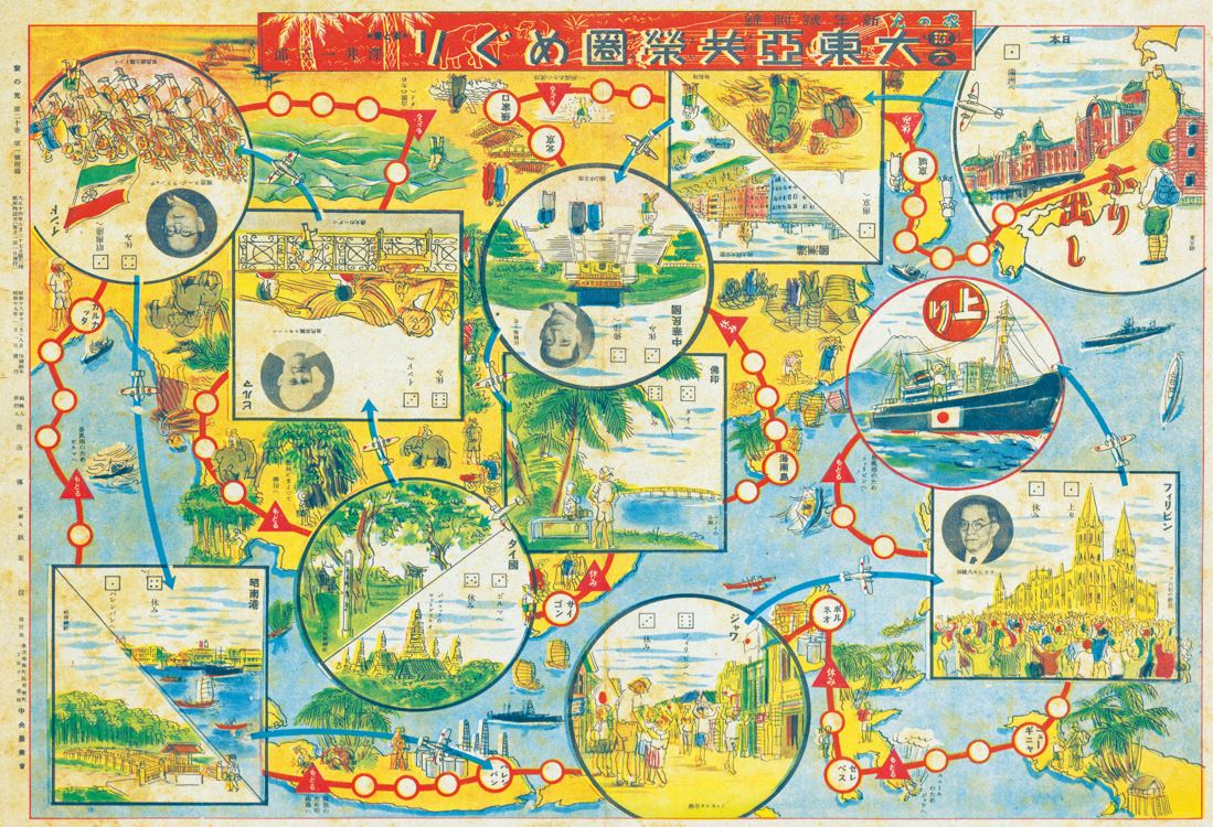
Printed in 1944 as a magazine supplement, this board game titled 双六大東亞共榮圏めぐり: 新年號附録 (Sugoroku Dai Tōa Kyōeiken meguri: Shinnengō furoku) was designed to look like a map of the Greater East Asia Co-Prosperity Sphere (see Note 2). The game brings players on a tour of the various territories controlled by the Japanese during World War II. The illustrations depict landmarks in Asia, as well as Asian leaders (Wang Jingwei of China, Ba Maw of Burma, Subhas Chandra Bose of India and Jose P. Laurel of the Philippines), who had either collaborated with the Japanese to overthrow Western colonial rule or were installed as puppet heads of states in their own countries. Singapore is represented by a view of the city from the sea and the Syonan Jinja shrine in the MacRitchie Reservoir area, which commemorates Japanese soldiers who perished in the battles of Malaya and Sumatra. (Accession no.: B29245106G)
As a young man in the 1980s, Lim Shao Bin studied and worked in Japan, where he developed a lifelong passion for collecting Japanese historical materials on Singapore and Southeast Asia. As a student on a scholarship sponsored by a Japanese precision engineering company, Lim would make monthly trips to the office in the Kanda district in Tokyo to report on the progress of his studies.
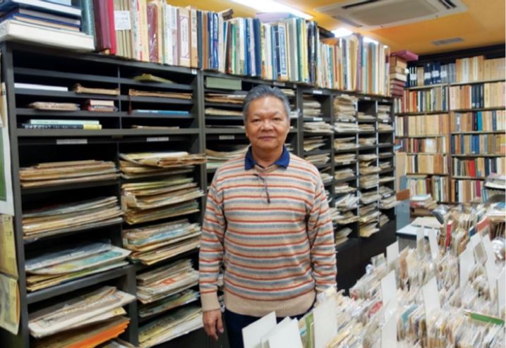
Lim Shao Bin at an antiquarian bookshop in Jinbōchō, Tokyo.
Just a stone’s throw away from the office was Jinbōchō, a district clustered with numerous bookshops, publishing houses and literary societies. At every corner and at every turn, trolleys and shelves of books would spill onto the pavements. After Lim was done at the office, he would explore these book-lined streets and, over time, began to discover rare materials on the subject of pre-war Singapore. As money was tight, Lim would occasionally skip a meal so that he could buy an old picture postcard of Singapore, which cost about ¥1,000 then.
On a more personal level, Lim’s purpose for collecting stems from a sense of deep loss over the death of his grandfather at the hands of Japanese soldiers in Malacca in 1945. In his quest to better understand the war, Lim began acquiring materials on Japan’s military history in Singapore and Southeast Asia. These items later went on to form the nucleus of his collection.
Over the course of the next 30 years and countless work and leisure trips to Japan, Lim painstakingly assembled a collection of over 1,500 items, some of which have been featured in books such as Images of Singapore: From the Japanese Perspective (1868–1941) published in 2004, and exhibitions like “Vignettes in Time: Singapore Maps and History Through the Centuries”, organised by the National Library Board and the Singapore Heritage Society in 2009.
Between 2016 and 2017, Lim donated a selection of his precious Japanese memorabilia to the National Library Board in three tranches. His intention was to make these items accessible for research and, in the process, educate younger generations of Singaporeans on our war history.
Lim retired from a senior management position at Sony in 2018 and now devotes his time to the study and research of Singapore and Southeast Asia and their interactions with Japan during the World War II period.
Overview of the Collection
In total, the donation comprises more than 800 items: Japanese wartime maps on Southeast Asia; commemorative books, atlases and photographs; newspapers covering Japan’s military campaign in Singapore and Malaya; picture postcards depicting scenes of early Singapore; and postal covers and letters written by the Japanese diaspora in pre-war Singapore.
Most of the materials are in Japanese and date from the mid-Meiji (1868–1912) to early Showa (1926–89) eras. The earliest item in the collection is a postal cover of a registered mail sent from the Medical Hall in Singapore to Japan in 1885. Two main themes can be discerned on closer inspection of the items: the pre-war Japanese community in Singapore, and Japan’s military expansion and subsequent occupation of Southeast Asia.
Although Japanese immigrants have been coming to Singapore since 1862,1 records of this little-known, pre-war community are few and far between. The Lim Shao Bin Collection of Japanese historical materials on Southeast Asia has significantly strengthened the library’s holdings of this subject as well as the war period which, until now, has been largely confined to printed works on the Japanese military campaign and the occupation of Singapore and Malaya between 1942 and 1945.
With this donation, the library now has a more comprehensive record of the Japanese presence in Singapore, beginning from the Meiji era. The addition of significant Japanese wartime sources to existing British and Australian accounts has also made it possible to study the Pacific War from both sides of the conflict, thereby bringing new perspectives and insights to the topic.
Collection Highlights
Maps and Atlases
The cartographic collection contains more than 130 maps and atlases on Southeast Asia dating from the 1860s to 2000s. While most are Japanese maps produced during the Taisho (1912–26) to the early Showa (1926–89) periods, there are also some non-Japanese maps in the collection; the oldest, in fact, is an 1862 map of British India.
There are different types of maps in the collection: world, regional (e.g. East Asia, Southeast Asia), country/area (e.g. Burma, Sumatra) and city/town (e.g. Malacca, Taiping, Palembang, Cebu, Manila).
The maps record valuable information such as geopolitical boundaries, location of economic resources, transportation routes, climate data, population figures, city layouts, military infrastructure as well as battle plans and conquests in Southeast Asia. Collectively, the maps demonstrate the extent of data-gathering and research before World War II that Japan carried out on Southeast Asia and the interest that it had shown in its southern neighbours.
Postcards and Letters
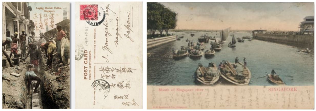
Dating from the Meiji (1868–1912) to the early Showa (1926–89) eras, the philatelic collection comprises some 500 picture postcards – in colour as well as black-and-white – mostly depicting streets, buildings and the Asian inhabitants of colonial Singapore.
The postcards showcase familiar thoroughfares such as Battery Road, High Street, North Bridge Road, Orchard Road and Serangoon Road, and places like Boat Quay, Tanjong Katong and Tanjong Rhu. A handful feature less frequently seen views of the island, such as the granite mine at Bukit Timah and the old police station on Pasir Panjang Road. The collection also contains some letters and postal covers.
About a third of the postcards were printed in Japan, with several containing handwritten messages by Japanese and European residents living in Singapore. These were primarily addressed to family, friends and business associates back in Japan, and are potentially useful for studying the social networks and lives of Japanese residents in Singapore.
One of the unique highlights of the philatelic collection is an album of Japanese postcards assembled by Lim on the theme “Singapore on a map”. The postcards feature illustrations of maps with Singapore as a port of call along the transnational routes of Japanese ocean liners, and as one of several Japanese-occupied territories in the Greater East Asia Co-Prosperity Sphere2 during the Pacific War. A number of these postcards contain stamps and postmarks commemorating the fall of Singapore as well as the first and second anniversaries of the Greater East Asia War (the Japanese name for the Pacific War).
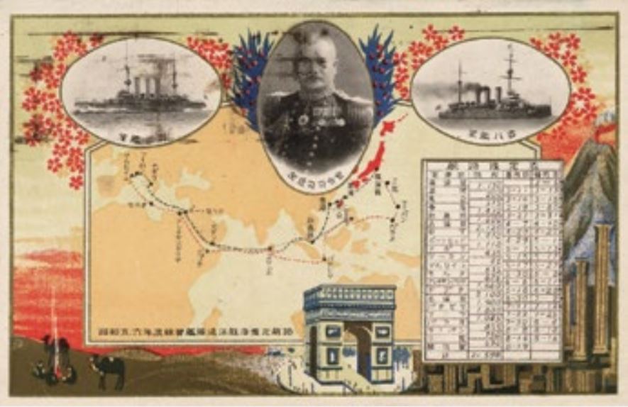
Among the postcard collection is also a series of 13 postcards depicting the Russo-Japanese War (1904–1905) with postmarks from Singapore. These souvenir postcards were among the earliest commercial postcards produced in Japan, and their popularity led to a subsequent boom in the production and use of postcards in Japan.
Books
Among the items are eight books, mostly works documenting the Japanese military campaign in Southeast Asia, photographs and war art published by press agencies in Japan such as Domei News Agency and Asahi Shinbun as well as the Japanese military.
There are also two books produced in Singapore documenting the pre-war Japanese community in Southeast Asia. The first, 馬來に於ける邦人活動の現況 (Marai ni okeru hōjin katsudō no genkyō), published by Nanyō Oyobi Nihonjin Sha (South Seas and the Japanese Press) in 1917, provides an overview of Japanese activities in Malaya. The second book, 南洋之産業. 壹之卷 = Tropical industry (Nan’yō no sangyō. Ichi no ken =Tropical industry), published in 1920 by the Japanese Commercial Museum in Singapore describes the tropical industries of Southeast Asia.
Newspapers
The collection includes 27 newspaper issues published between 1941 and 1942 in the early stages of the Pacific War, and in 1945 during the Japanese surrender. The newspapers provide an interesting study of how the same events are covered and interpreted differently by Japanese and Western media. The newspaper selection includes the Asahi Shinbun, Tokyo Nichi Nichi Shinbun, Yomiuri Shinbun, Hochi Shinbun, The Daily Telegraph, Daily Mail, The New York Times, The Daily Express, Los Angeles Examiner and the Rochester Times-Union.
Posters
There are six large-format American World War I posters in the collection. These were used to recruit members for the US armed forces as well as encourage the American public to buy government war bonds in aid of military operations and expenses.
), which marks out 83 landmarks and locations of interest such as government and commercial buildings. An accompanying booklet (an inside page shown here) contains photographs of the places and landmarks found on the map. The map was most likely used by the Japanese military to requisition important buildings in Singapore after the British surrender. (Accession nos.: B29245121D [map]; B29255626D [booklet]).](https://isomer-user-content.by.gov.sg/339/8405c894-0bdf-4a7e-b429-068744631b23/Collection3.JPG)
As part of reconnaissance efforts, the Japanese military prepared detailed maps of key cities in Southeast Asia in the 1930s, including this one of Singapore titled 新嘉坡市街図 ([Shingapōru shigai chizu), which marks out 83 landmarks and locations of interest such as government and commercial buildings. An accompanying booklet (an inside page shown here) contains photographs of the places and landmarks found on the map. The map was most likely used by the Japanese military to requisition important buildings in Singapore after the British surrender. (Accession nos.: B29245121D [map]; B29255626D [booklet]).
![This 1929 map, 南洋ニ於ケル邦人栽培企業現勢圖 ([Nan’yo ni okeru hojin saibai kigyo genseizu]), includes seven charts that compare the cultivation, investment and consumption of rubber by Japan with the rest of the world. Also included is a diagram that shows the distance between Singapore and other major ports in Southeast Asia, highlighting the importance of Singapore as an export centre for half of the world’s rubber supply that was produced in Malaya at the time. Southeast Asia’s rich natural resources was one of the primary reasons cited for Japan’s military advance into Southeast Asia during World War II. (Accession no.: B29245119K)](https://isomer-user-content.by.gov.sg/339/b5abbaed-13d4-48e9-8cdd-4f4e82f6d3c9/Collection4.JPG)
This 1929 map, 南洋ニ於ケル邦人栽培企業現勢圖 (Nan’yo ni okeru hojin saibai kigyo genseizu), includes seven charts that compare the cultivation, investment and consumption of rubber by Japan with the rest of the world. Also included is a diagram that shows the distance between Singapore and other major ports in Southeast Asia, highlighting the importance of Singapore as an export centre for half of the world’s rubber supply that was produced in Malaya at the time. Southeast Asia’s rich natural resources was one of the primary reasons cited for Japan’s military advance into Southeast Asia during World War II. (Accession no.: B29245119K)
![Printed on 2 March 1942, about two weeks after the fall of Singapore, this map titled 馬來半島及昭南島(新嘉坡島)精圖; 昭南港(新嘉坡)市街地圖 ([Marai hantō oyobi Shōnantō [Shingapōrutō] seizu; Shōnankō [Shingapōru] shigai chizu])marks the location of 78 Japanese businesses in Syonan City with street names given in English. On the reverse are maps of the Malay Peninsula and Syonan Island (Singapore), with the locations and names of the 11 mines and 25 rubber plantations owned by Japanese citizens. The map of Syonan City is based on an earlier city map published by the Singapore Japanese Club in 1938. (Accession no.: B29245124G)](https://isomer-user-content.by.gov.sg/339/e389f33e-05b8-45a6-b0f9-8d34ff11c4d9/Collection5.JPG)
Printed on 2 March 1942, about two weeks after the fall of Singapore, this map titled 馬來半島及昭南島(新嘉坡島)精圖; 昭南港(新嘉坡)市街地圖 ([Marai hantō oyobi Shōnantō [Shingapōrutō] seizu; Shōnankō [Shingapōru] shigai chizu])marks the location of 78 Japanese businesses in Syonan City with street names given in English. On the reverse are maps of the Malay Peninsula and Syonan Island (Singapore), with the locations and names of the 11 mines and 25 rubber plantations owned by Japanese citizens. The map of Syonan City is based on an earlier city map published by the Singapore Japanese Club in 1938. (Accession no.: B29245124G)
![Prepared by the Japanese 25th Army in February 1942, this map titled 新嘉坡嶋に於ける敵軍戦闘指導要領要図 ([Shingapōru ni okeru tekigun sentō shidōyōryō yōzu]) details one course of attack on Singapore. It involved the capture of Seletar and an invasion from the north-east of the island. The intended plan of action is outlined in blue text on the top right-hand corner of the map. (Accession no.: B29245125H)](https://isomer-user-content.by.gov.sg/339/6b884d1b-c681-4e14-bfd1-ecc7246333d6/Collection6.JPG)
Prepared by the Japanese 25th Army in February 1942, this map titled 新嘉坡嶋に於ける敵軍戦闘指導要領要図 ([Shingapōru ni okeru tekigun sentō shidōyōryō yōzu]) details one course of attack on Singapore. It involved the capture of Seletar and an invasion from the north-east of the island. The intended plan of action is outlined in blue text on the top right-hand corner of the map. (Accession no.: B29245125H)
Printed in 1944 as a magazine supplement, this board game titled 双六大東亞共榮圏めぐり: 新年號附録( [Sugoroku Dai Tōa Kyōeiken meguri: Shinnengō furoku) was designed to look like a map of the Greater East Asia Co-Prosperity Sphere (see Note 2). The game brings players on a tour of the various territories controlled by the Japanese during World War II. The illustrations depict landmarks in Asia, as well as Asian leaders (Wang Jingwei of China, Ba Maw of Burma, Subhas Chandra Bose of India and Jose P. Laurel of the Philippines), who had either collaborated with the Japanese to overthrow Western colonial rule or were installed as puppet heads of states in their own countries. Singapore is represented by a view of the city from the sea and the Syonan Jinja shrine in the MacRitchie Reservoir area, which commemorates Japanese soldiers who perished in the battles of Malaya and Sumatra. (Accession no.: B29245106G)
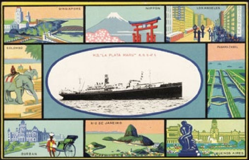
Postcards issued by Japanese shipping companies, such as Nippon Yusen Kaisha and Osaka Shosen Kaisha, identified Singapore as one of the strategic ports of call along their liner and cargo routes. This undated postcard by the Osaka Shosen Kaisha features wellknown landmarks and scenes of the various ports of call – including Singapore, Colombo, Los Angeles and Rio de Janeiro – of the MS La Plata Maru. (Accession no.: B32413808G)
A postcard commemorating the historic visit by Crown Prince Hirohito (later Emperor Showa) to Europe in 1921. The royal entourage stayed in Singapore from 18 to 22 March 1921 whilst en route to Europe. (Accession no.: B32413808G)
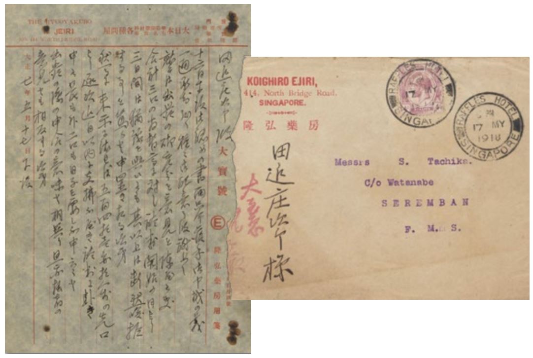
The first page of a letter from Koighiro Ejiri of Ryuoyakubo, a Japanese drug store at 414 North Bridge Road, addressed to a Watanabe of Messrs S. Tachika in Seremban, Malaya, describing the Japanese and Chinese medical supplies sold in the store. The letter illustrates the personal connections between Japanese residents in Singapore and Malaya as well as the business networks that existed between Singapore, Xiamen (China) and Japan. The envelope is postmarked 17 May 1918 from the post office that used to operate at Raffles Hotel. In the early 20th century, many Japanese-owned shops were located on Middle Road (which was known as Little Japan back then) and North Bridge Road. (Accession no.: B32413805D)
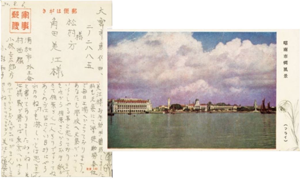
A Japanese postcard featuring the waterfront and skyline of Syonan City (Singapore) dated 6 August 1945. Visible from the photo is the General Post Office (today’s Fullerton Hotel), the Victoria Theatre and Concert Hall, the old Supreme Court and Municipal Building (today’s National Art Gallery) and St Andrew’s Cathedral. The writer, Wako Kobayashi, describes her life as an apprentice in a factory and her future plans when the war ends. She encourages Mie Kakuda, the addressee of this postcard, to press on during this time of adversity. (Accession no.: B32413808G)
Picture postcards of colonial Singapore. Some of these carry messages written by Japanese residents or tourists visiting Singapore. They were sent to family, friends and business associates back in Japan, although a small number are addressed to other Japanese residents living in Malaya. About a third of the 500 postcards were printed in Japan. The names of studios and photographers are usually not stated on the cards but a few include the names of Japanese studios in Singapore and Malaya, such as Togo & Co. (Singapore), Hakone Studio (Melaka) and M. Nakajima (Kuala Lumpur). There are also cards produced by non-Japanese studios and stationers in Singapore like G.R. Lambert, Max H. Hilckes, Wilson & Co., Continental Stamp Co. and Koh & Co. (Accession no.: B32413805D)
Singapore was one of the ports of call for the Imperial Japanese Navy’s training missions in the 1920s and 30s. This postcard commemorates a training cruise to Marseille, France, led by Vice-Admiral Seizō Sakonji. The two battleships, Izumo and Yakumo, docked in Singapore between 27 and 31 March 1931. During his time on the island, Vice-Admiral Sakonji met with leading members of the Japanese community. (Accession no.: B32413808G)
![A pictorial book published in 1920 by the Japanese Commercial Museum in Singapore. Titled南洋之産業. 壹之卷 = Tropical Industry ([Nan’yō no sangyō. Ichi no ken]), the book describes the cultivation and processing of rubber, oil palm, tobacco, tea, rice, tapioca, tin, hemp, timber, coffee and fruits in Southeast Asia. (Accession no.: B29262851B)](https://isomer-user-content.by.gov.sg/339/4c3aaf9c-3705-45a5-b803-658654e1293c/Collection12.JPG)
A pictorial book published in 1920 by the Japanese Commercial Museum in Singapore. Titled南洋之産業. 壹之卷 = Tropical Industry ([Nan’yō no sangyō. Ichi no ken]), the book describes the cultivation and processing of rubber, oil palm, tobacco, tea, rice, tapioca, tin, hemp, timber, coffee and fruits in Southeast Asia. (Accession no.: B29262851B)
![Published in 1917, this pictorial book, 馬來に於ける邦人活動の現況 ([Marai ni okeru hōjin katsudō no genkyo]), which comprises two parts, provides an overview of Japanese activities in Malaya during the Taisho era (1912–26). Part 1 consists of more than 100 black-and-white as well as coloured plates – along with short captions – depicting landscapes, social life and the customs of the Malay Peninsula, with a section devoted to the cultivation of rubber. Part 2 consists mainly listings and descriptions of rubber and coconut plantations and tin mines owned by the Japanese in the region, as well as a directory of Japanese nationals living here and their occupations. (Accession no.: B29262852C)](https://isomer-user-content.by.gov.sg/339/f887e4c2-2e93-4132-b11f-43a72ca5ffe6/Collection13.JPG)
Published in 1917, this pictorial book, 馬來に於ける邦人活動の現況 ([Marai ni okeru hōjin katsudō no genkyo]), which comprises two parts, provides an overview of Japanese activities in Malaya during the Taisho era (1912–26). Part 1 consists of more than 100 black-and-white as well as coloured plates – along with short captions – depicting landscapes, social life and the customs of the Malay Peninsula, with a section devoted to the cultivation of rubber. Part 2 consists mainly listings and descriptions of rubber and coconut plantations and tin mines owned by the Japanese in the region, as well as a directory of Japanese nationals living here and their occupations. (Accession no.: B29262852C)
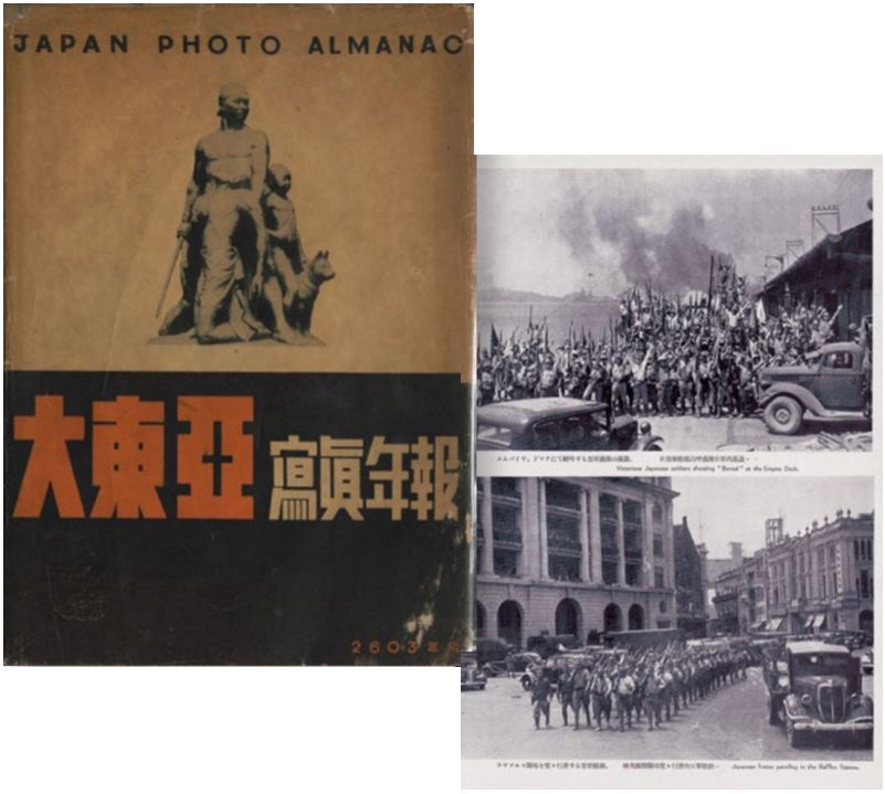
This 1943 book, 大東亜写真年報 = Japan Photo Almanac. 2603年版 ([Daitōa shashin nenpō = Japan Photo Almanac. 2603 nenban), contains photographs of all Japanese-invaded terrorities under the Greater East Asia Co-prosperity Sphere (see Note 2). Featured on this page are images of victorious Japanese soldiers in Singapore shouting “Banzai” (meaning “10,000 years of long life”) at the Empire Dock in Keppel Harbour, and taking part in a victory parade in Raffles Square. (Accession no.: B29244788K)
The author wishes to thank Lim Shao Bin and librarians Goh Yu Mei and Ng Hui Ling for their input. Digital versions of some of the items featured in this article are available on BookSG at [National Library Online](https://www.nlb.gov.sg/main/nlonline).
About the Author
Gracie Lee is a Senior Librarian with the National Library, Singapore. She works with the rare materials collections, and her research areas include Singapore’s publishing history and the Japanese Occupation.
Endnotes
1 The first Japanese settler, Yamamoto Otokichi, came to Singapore in 1862. See Tan, B. (2016, Jul–Sep). Singapore’s first Japanese resident: Yamamoto Otokichi. BiblioAsia, 12 (2), 32–35.
2 The Greater East Asia Co-Prosperity Sphere refers to Japan’s wartime empire in Asia, promoted under the guise of mutual benefit and Asian unity.