
Article
The Making of Merdeka Bridge and Nicoll Highway
18 October 2026
Topics
History
Places and Buildings
Opened in 1956, Merdeka Bridge and Nicoll Highway reshaped Singapore’s eastern coastline, and transformed the way people travelled between the city and the suburbs.
By Lim Tin Seng
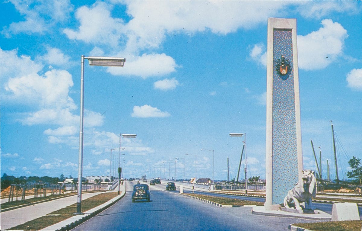
One of the stone lions and its accompanying 9-metre-tall mosaic pylon at one end of Merdeka Bridge, 1960s. Collection of the National Museum of Singapore, courtesy of National Heritage Board.
On the “lovely, cool evening” of 17 August 1956, “[in] a proud, truly national spirit the people of Singapore, in their tens of thousands… took part joyously in the opening of the Merdeka Bridge and Nicoll Highway,” the Straits Times reported. Under an evening sky of “pearly hue” against the backdrop of the hangars of the former Kallang Airport, they were there to witness Chief Minister Lim Yew Hock declare the opening of the bridge and road.1
For a population navigating the twilight of British colonial rule, the completion of Merdeka Bridge and Nicoll Highway marked the island’s journey to self-government. Accompanied by the First Battalion of the Singapore Volunteer Corps and the tunes of the Singapore Police Force Band, Lim linked the bridge to Singapore’s aspiration for “Merdeka” (Malay for “freedom” or “independence”): “[T]his Merdeka Bridge symbolises for us the spirit in which we will achieve merdeka, through calm and thoughtful planning and through painstaking laying of a stable solid foundation. It is a reminder that merdeka is not a matter of building the spirit of independence only, but of building the skeleton and flesh of merdeka.”2
On a practical front, however, Merdeka Bridge and Nicoll Highway were conceived to resolve the worsening traffic congestion in the Kallang area which was described as “shocking” and a “nightmare”. As Lim noted in his speech: “[T]his is a bridge into the future… It relieves us of the nightmare of the bottleneck at Kallang.”3
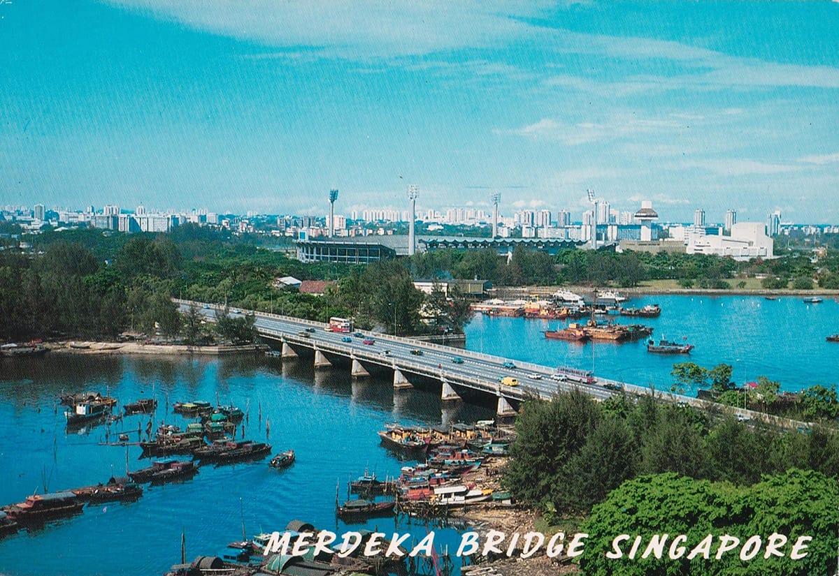
Aerial view of Merdeka Bridge, mid-1970s. In the background on the right is the former National Stadium. Collection of the National Museum of Singapore, National Heritage Board.
A Coastal Road to the East
The idea of constructing a coastal road stretching from the Padang to Kallang was not new. The government had been exploring this as early as 1939 after a special committee was appointed for the Beach Road reclamation scheme. The road would provide motorists with a scenic “waterfront drive” from Anderson Bridge to Kallang. Although the proposal was “approved in principle”, its implementation was halted by the outbreak of World War II.4
When the war ended, the same committee reconvened in 1947 to revisit its findings. In its updated 1948 report, the committee not only revived the waterfront coastal road proposal, but also expanded it to reach Mountbatten Road via a new bridge over the Kallang River. However, the recommendation remained on the back burner for a number of years until the worsening traffic conditions in the area during the early 1950s forced the colonial government to reconsider.5
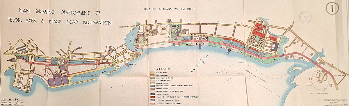
Plan showing the proposed coastal road route (in red) stretching from Connaught Drive to Kallang. Image reproduced from "Report on the Proposed Re-development of the Coastal Area: Mountbatten Road – East Reclamation Road, July 1948" (Singapore: Govt. Print. Off., 1948). (From National Library of Singapore, call no. RCLOS 711.3 SIN).
By then, the traffic situation on Singapore roads had deteriorated to a state of “frightful” chaos. The gridlock was largely driven by a massive postwar population boom and rapid suburban expansion into areas like Tanglin to the north, and the Katong-Geylang area and beyond to the east. Residents faced a gruelling daily commute to their workplaces in the town area.6
The commuting problem was further exacerbated by a total lack of alternative routes. At the time, Kallang Road was the only major artery connecting the east coast to the town area. A traffic census by the Public Works Department (PWD) in 1954 revealed that during peak hours, more than 2,200 vehicles per hour in each direction jostled for space on Kallang Road. Compounded by frequent roadworks, it was common for motorists to be stuck on the road for “as long as 25 minutes [while] lining up four abreast over a considerable distance”.7
To ease the situation, the government launched a series of stopgap measures ranging from tighter traffic controls to one-way traffic schemes.8 However, these failed to alleviate the congestion but instead invited sharp criticisms from the public and the Legislative Council.9 Bowing to systemic pressure, the government finally agreed in February 1953 to “press on with the Coast Road project and the new bridge over Kallang River”, both of which were described as “long overdue”.10
Projected to cost some $11.5 million, the blueprint – revealed in June 1953 – involved extending Esplanade Road along the Beach Road reclamation site via a new coastal road that would run directly to the mouth of the Kallang River before leading to a bridge. From there, the road would cut across the runway of the soon-to-be-decommissioned Kallang Airport to meet Mountbatten Road at its junction with Guillemard Road, where a roundabout would be built.11
Designing the Bridge and Highway
The new costal road and bridge scheme, led by the City Council and PWD respectively, was deemed as “very high priority” and envisaged to be completed within two years, by mid-1956.12
Preliminary investigations – surveys, deep borings, test pilings and soil samplings – were conducted in July 1953 to determine the ultimate design of the proposed bridge. These tests confirmed that the subsoil at the Kallang Basin site was of “poor quality” with parts of it reaching up to 21 m deep. To overcome this, the PWD settled on a 610-metre-long prestressed concrete bridge divided into 25 spans, each measuring 24 m. Each span rested on heavy, precast reinforced concrete piles – which was then a new building technology – with some having to be driven down as deep as 40 m for greater stability.13
Merdeka Bridge was designed by PWD Superintending Engineer of Major Works R.J. Hollis-Bee, the “first major girder bridge” in Malaya and Singapore at the time. It was planned to be 20 m wide to accommodate two lanes of carriageways on each side, as well as a walkway for pedestrians, cyclists and trishaws, with the potential to expand to a maximum 29 m for an extra lane on each side. There was also a 3-metre headroom clearance beneath the bridge for “crafts without masts” to pass through.14
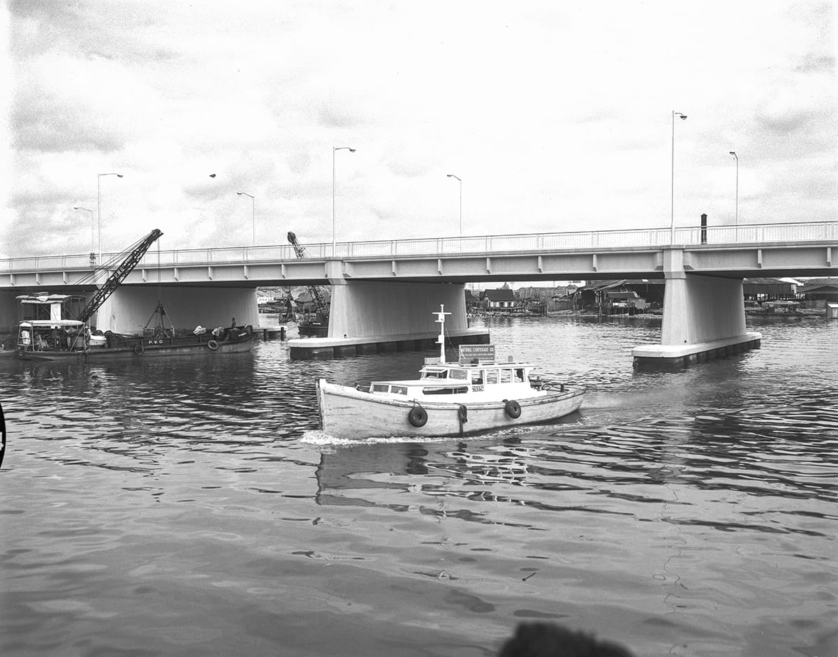
Merdeka Bridge has a 3-metre headroom clearance for small vessels to pass under, 1956. Ministry of Information and the Arts Collection, courtesy of National Archives of Singapore (Media - Image No. 19980001282 - 0025).
The new coastal road leading to and away from the bridge would not have any intersections to “ensure that traffic entering and leaving the city will move in an uninterrupted flow”. Led by the City Council’s City Engineer B.E. Thompson, the coastal road would be built entirely on land previously reclaimed along the Beach Road seafront on the western end of the bridge as well as on the runway of the former Kallang Airport on the eastern end. As the soil at the site of the new road was either “very poor” or consisted of “slow easy flowing muds and clays varying in depth”, 130,000 tons of hard filling material were brought in from the quarry at Jalan Eunos to create the necessary firm surface.15
At the western end of the road, a smaller and shorter bridge called Stamford Bridge was constructed over the Stamford Canal. This bridge was 30.5 m long and 28.7 m wide, and built so that the coastal road could cross the mouth of Stamford Canal to connect to Connaught Drive.16 Although Stamford Bridge no longer exists today, the two structures that used to mark its piers, each measuring a metre tall, still remain.17
Construction Delays and Tender Controversies
Although the bridge’s design and the coastal road’s alignment had been secured, physical execution of the project could only begin after overcoming several early obstacles, including the immediate need to clear the worksite of illegal squatters and light industries. Back then, some 600 charcoal and firewood traders and 400 squatters occupied the Beach Road reclamation area. Plans were drawn up to relocate the traders to a new centre in Tanjong Rhu and the squatters to a public housing estate on Guillemard Road.18
Beyond resettlement hurdles, there were also unexpected disruptions. Between 1954 and 1955, a London dock strike and a local labour strike threatened foundation and river-channelling work. Furthermore, the unpredictable subsoil conditions at the western end of the bridge compelled further soil tests to determine ground stability, although piling work had been completed and the official construction tender had been called in October 1954.19
The procurement process came under public scrutiny after the government announced in December 1954 that the contract for the construction of Merdeka Bridge had been awarded to Paul Y. Construction Company, a local firm associated with Hume Industries and Sime Darby, even though Paul Y. Construction had submitted the highest bid.
Critics pointed out that the firm was “comparatively new”, possessed zero experience in constructing prestressed concrete bridges, and even had to subcontract both the foundation work and the beam manufacturing to other companies.20 Questions also arose as to why Paul Y. Construction was selected despite being the only bidder that failed to submit an alternative bridge design as stipulated in the tender.
At the 28 January 1955 meeting of the Legislative Council, Colonial Secretary W.A.C. Goode explained that Paul Y. Construction secured the contract because it was “the only one which complied with PWD requirements”. He argued that the competing tenderers had proposed pile designs that were either structurally unsuitable or lacked adequate steel reinforcement.21
Despite the lingering controversy, the government stood firm and rejected all calls to reconsider the award.
Building and Naming the Infrastructures
To construct the bridge, the PWD erected a temporary earth dam, or bund, inside the Kallang Basin to divert the river. Completed in November 1954, the dam allowed workers to operate on dry land, improving efficiency and saving an estimated $6.5 million in construction costs.22
The bridge structure was assembled using either components cast on-site (in situ), or built from precast concrete units manufactured in temporary yards and transported into position on rail bogies. The foundational piles and vertical piers were built with standard reinforced concrete, while the flat deck slab and main horizontal beams, each weighing nearly 30 tons, used prestressed concrete. This technology was so new at the time that Merdeka Bridge was among the first prestressed concrete bridges built outside the United States.23
The bridge was targeted to be completed by June 1956, “a record” 15 months. “Work on the bridge has so far progressed very harmoniously,” Hollis-Bee told the Singapore Standard in March 1956. “The contractor and sub-contractors have been very co-operative in the task with members of the Public Works Department staff and it is because of this that the work has gone ahead so quickly and accurately.”24
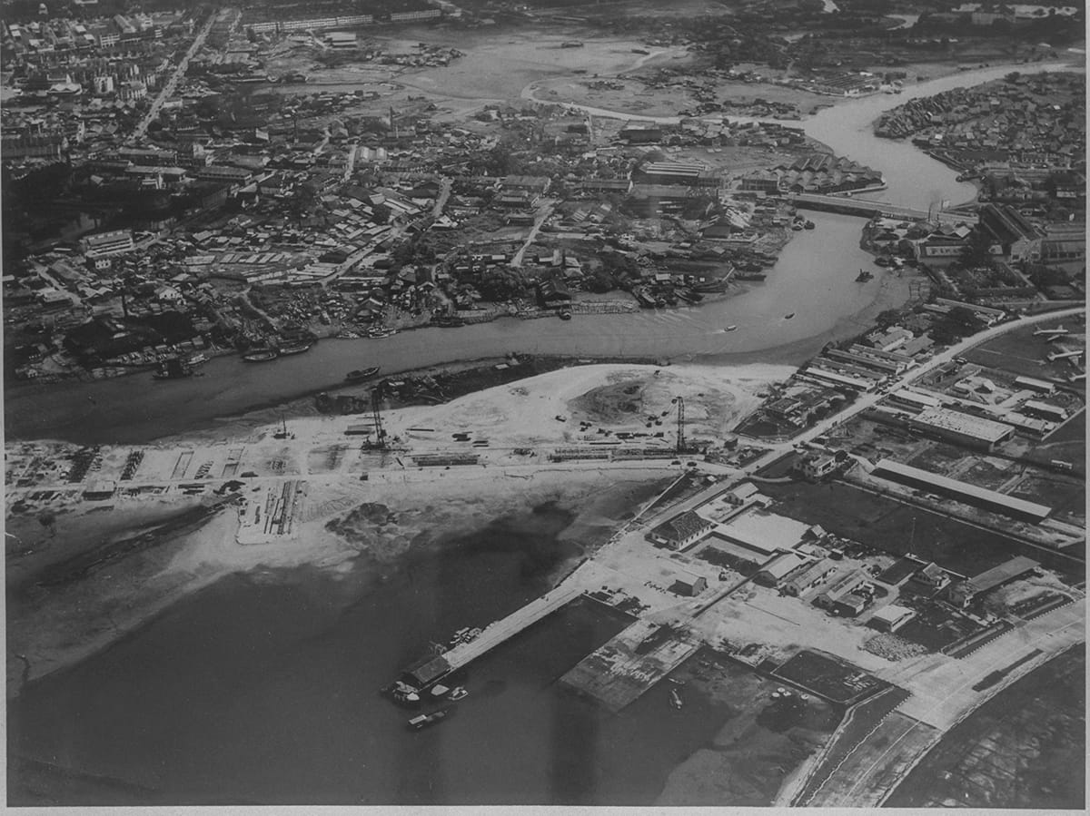
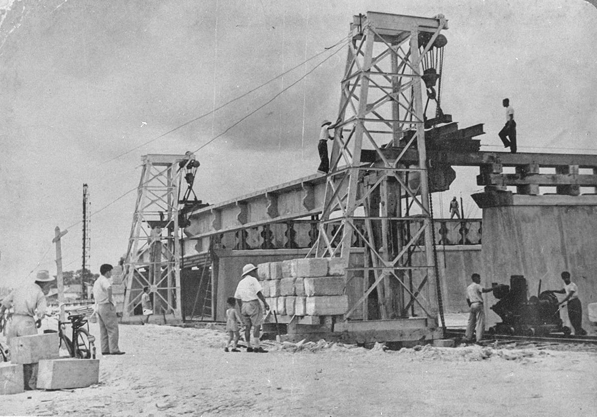
Although contractors engaged by the City Council had begun work on the accompanying coastal road in September 1954, its progress was held back by the remaining charcoal and firewood traders who had refused to relocate to their new sites in Tanjong Rhu.25 The authorities eventually negotiated their removal, and the City Council immediately cleared the site of the physical obstructions left behind, including small huts, sawmills and timber yards that “densely covered” parts of the work site.26
The completion of the bridge and coastal road coincided with a period of political change in Singapore, which had achieved internal self-government on 8 February 1955 and held the first Legislative Assembly general election on 2 April that year. As a result, Minister for Communications and Works Francis Thomas announced on 21 June 1956 that the bridge would be named Merdeka Bridge because “it expresses the confidence and aspirations of the people”. Just a week later, on 30 June, the City Council named the accompanying road Nicoll Highway after former Governor John Nicoll, in recognition of the “drive and energy” he had given to allow the road to be built.27
To anchor this new identity, the bridge was adorned on both ends with a pair of identical, two-and-a-half-ton stone lions, which were referred to as the “Merdeka Lions”. These were designed by Architect L.W. Carpenter of the Public Works Department and sculpted in Manila under the direction of Hong Kong-based Italian artist Raoul Bigazzi. Each lion was accompanied by a 9-metre-tall monumental pylon decorated with vibrant blue mosaic tiling and crowned with the official crest of the City of Singapore. Standing as “Freedom Guardians”, the two stone lions also symbolise Singapore as the “Lion City”.28
Official Opening
The official opening of Merdeka Bridge and Nicoll Highway on 17 August 1956 was a grand occasion attended by a crowd of 60,000 spectators and some 500 invited guests, including guest of honour Chief Minister Lim Yew Hock, the bridge’s designer Hollis-Bee and Acting City Council President R. Middleton-Smith.29
After the opening speeches, religious leaders representing six major faiths – Islam, Buddhism, Christianity, Hinduism, Judaism and Sikhism – held a joint service to bless the bridge.30 Celebrations began as a plane swooped low to shower the crowd with fresh roses and souvenir leaflets. The official party then marked the end of the ceremony by boarding three open-top Land Rovers to cross and inspect the bridge. The scene burst into a spontaneous “unrehearsed and unexpected” moment of public joy as the crowds surged past police rope barriers at both ends of the bridge to cross it for good luck. Flooding the entire stretch, the two groups surged forward as if to greet one another from both ends, transforming the bridge into “a seething mass of happy humanity”.31
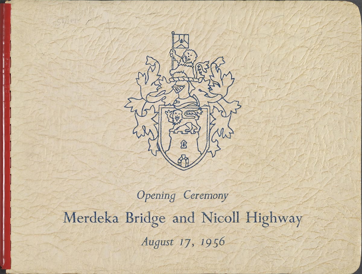
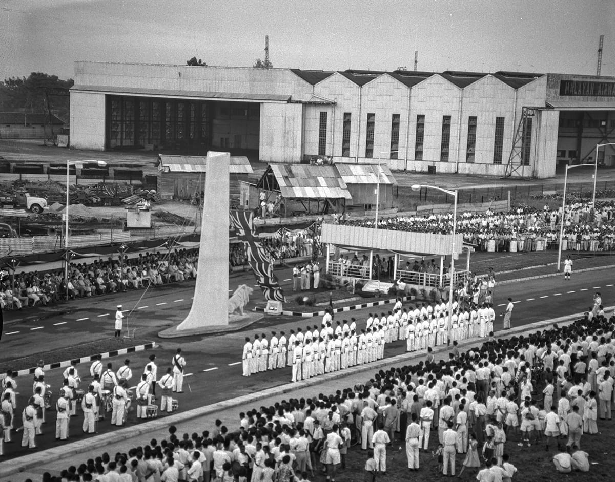
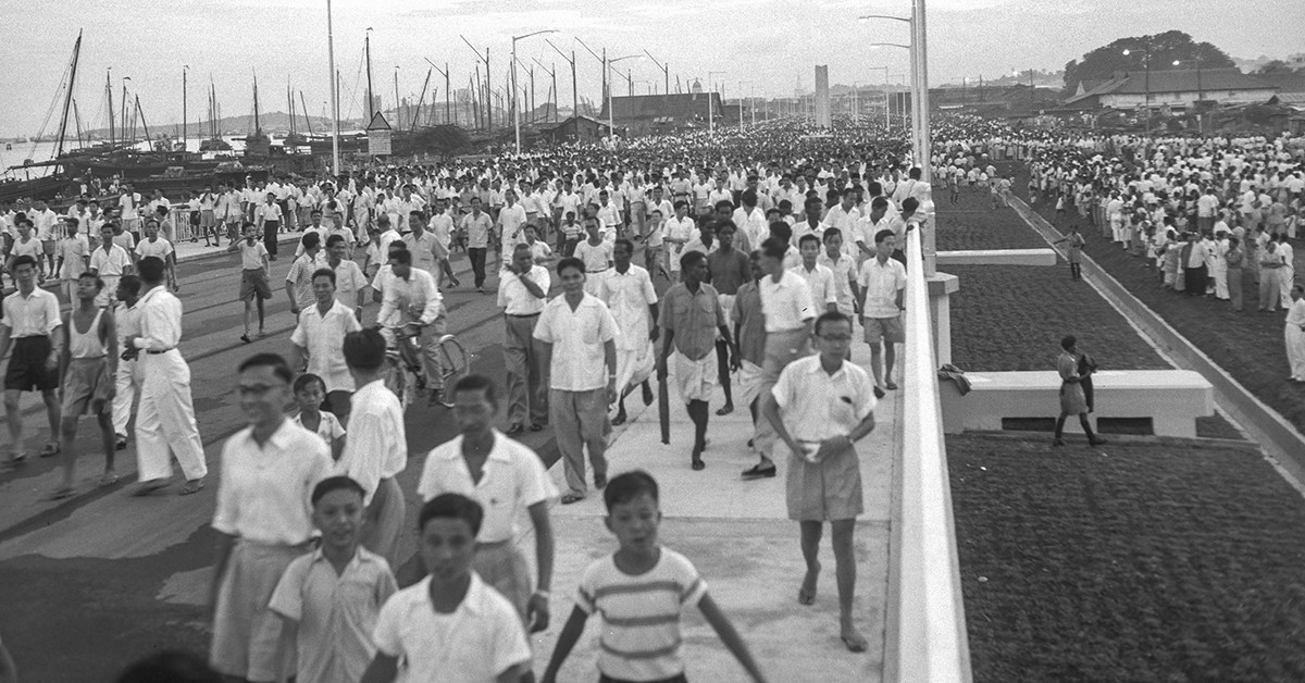
The new coastal thoroughfare was hailed as a welcome reprieve after years of gruelling commutes across the Kallang Basin, with commuters calling it the “saver of hundreds of man-hours”. Motorists reported that “travel time to the city [was] cut by 25 to 35 minutes despite a 20 m.p.h. speed-limit until the final surfacing of the road [was] completed” in January 1957. The time motorists saved in these early months roughly equalled what they had previously spent stuck in evening rush-hour gridlock along Kallang Road.32
As Merdeka Bridge and Nicoll Highway were vital arterial lifelines and a symbol of Singapore’s journey to self-government, they became prime targets during Indonesia’s Konfrontasi campaign (1963–66) against the formation of Malaysia. Indonesian saboteurs targeted the bridge twice when they planted explosives there in May 1964 and July 1964. Although the first bomb created a crater measuring 30.5 cm wide and 15 cm deep, and the second caused a hole 91 cm long and 7.6 cm deep, these “did not cause much damage” and no one was injured.33
Expansion and Reversible Tidal Flow
Unfortunately, within two years of the opening of Merdeka Bridge and Nicoll Highway, the very traffic gridlock they were built to resolve swiftly returned. The convenience of Nicoll Highway proved to be its own undoing. By providing a fast, direct route, it actively encouraged residents to drive or take buses to work. Driven by this surge, Nicoll Highway saw its peak traffic volume leap from 1,000 to 2,380 vehicles per hour from 1956 to 1958, outstripping its intended maximum design capacity of 2,100 vehicles per hour. By 1965, the initial four lanes had become “insufficient” to handle the volume of peak-hour traffic.34
The PWD embarked on a major widening scheme between 1965 and 1967. Merdeka Bridge was expanded to a total of seven lanes by adding an extra lane on each side and creating a shared lane down the middle. The entire stretch of Nicoll Highway was also widened in a similar arrangement.35 Unfortunately, the two lions and pylons had to be dismantled from both ends of the bridge in 1966. The lions were relocated to Stadium Walk near the entrance of Kallang Park. (They stood there until 1987 when the redevelopment of the area necessitated another move to the Singapore Armed Forces Training Institute at Pasir Laba Camp for storage. The lions were moved once again in 1995 to the new Singapore Armed Forces Training Institute in Jurong where they remain today.)36
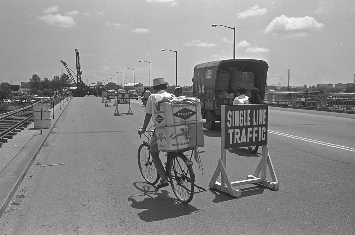
Traffic along Merdeka Bridge during the laying of new beams for its widening in 1967. Ministry of Information and the Arts Collection, courtesy of National Archives of Singapore (Media - Image No. 19980005326 - 0034).
The road expansion facilitated the implementation of the “reversible tidal flow system” in 1967 where the central lanes shifted direction during peak hours to optimise traffic flow. In the morning, city-bound traffic was allocated five lanes, while traffic leaving the city was restricted to two. This pattern was reversed during the evening rush hour.37 The “flexi-lanes” system finally ended in 1992 due to “better traffic distribution in the area throughout the day”, after almost three decades. In its place, the seven-lane configuration was converted into a “permanent two-way road of three-lanes each from Guillemard Road to Bras Basah Road”.38
In 2004, Nicoll Highway was struck by one of the worst civil engineering disasters in Singapore’s modern history. On 20 April, a catastrophic failure of a temporary retaining wall during the excavation for the Mass Rapid Transit Circle Line tunnel caused a section of the road to cave in, plunging the surrounding ground into a 30-metre-deep chasm. The disaster claimed four lives, including Foreman Heng Yeow Pheow, who sacrificed his life helping fellow workers escape before the collapse. The accident closed the vital road link for over seven months before reopening in December 2004.39
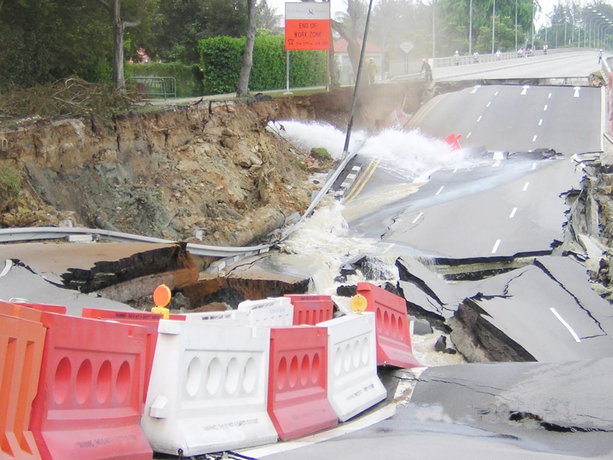
A stretch of Nicoll Highway caved in on 20 April 2004, caused by the collapse of a temporary retaining wall of a tunnel during the construction of the Mass Rapid Transit Circle Line. Collection of the National Library of Singapore.
Historic Designation
Today, Merdeka Bridge and Nicoll Highway remain vital arteries within Singapore’s urban transport network. While expressways like East Coast Parkway and Marina Coastal Expressway have since absorbed the bulk of long-distance coastal traffic, Merdeka Bridge stands as a resilient link across the Kallang Basin.
Beyond its functional utility, Merdeka Bridge came to embody Singapore’s aspirations for freedom and independence. Recognising this profound socio-political significance, the National Heritage Board officially designated Merdeka Bridge a historic site in 2002.40
About the Author
Lim Tin Seng is a Senior Librarian with the National Library of Singapore. He is the co-editor of Roots: Tracing Family Histories – A Resource Guide (2013), Harmony and Development: ASEAN-China Relations (2009) and China’s New Social Policy: Initiatives for a Harmonious Society (2010). He writes regularly for BiblioAsia.
End Notes
1 “Kallang Bridge Site Passes First Tests (opens in new tab),” Singapore Free Press, 9 July 1954, 5; Nan Hall, “Tens of Thousands Turn Out to Cheer (opens in new tab),” Straits Times, 18 August 1956, 1. (From NewspaperSG)
2 Hall, “Tens of Thousands Turn Out to Cheer (opens in new tab)”; Merdeka Bridge and Nicoll Highway: Opening Ceremony by the Chief Minister, the Honourable Mr. Lim Yew Hock on August 17, 1956 (opens in new tab) (Singapore: Govt. Print. Off., 1956), 2. (From National Library of Singapore, call no. RCLOS 624 MER-[RFL])
3 Merdeka Bridge and Nicoll Highway (opens in new tab), 3, 6; “Government Blamed for ‘Frightful’ Road Chaos (opens in new tab),” Straits Times, 12 February 1953, 8; “Solution to Singapore Motorists Nightmare (opens in new tab),” Sunday Standard, 28 August 1955, 9. (From NewspaperSG)
4 “$200,000 for Bigger Singapore Esplanade (opens in new tab),” Straits Times, 27 October 1939, 10; “Reclamation of Foreshore (opens in new tab),” Straits Times, 22 July 1940, 9. (From NewspaperSG)
5 “Colony Redevelopment Scheme (opens in new tab),” Straits Times, 6 September 1948, 5. (From NewspaperSG); Report on the Proposed Re-development of the Coastal Area: Mountbatten Road – East Reclamation Road, July 1948 (opens in new tab) (Singapore: Govt. Print. Off., 1948), 1–6. (From National Library of Singapore, call no. RCLOS 711.3 SIN)
6 “Government Blamed for ‘Frightful’ Road Chaos (opens in new tab)”; Amy Laycock, “Give Priority to New Coast Road (opens in new tab),” Straits Times, 4 September 1952, 6; “Katong (opens in new tab),” Singapore Monitor, 16 December 1984, 6; “Area Used to Be Seaside Resort (opens in new tab),” Straits Times, 24 November 1996, 2; E.H.G. Dobby, “Our Mudbank City Is Comparable to Washington (opens in new tab),” Singapore Standard, 22 September 1951, 1. (From NewspaperSG)
7 “Solution to Singapore Motorists Nightmare (opens in new tab),” Sunday Standard, 28 August 1955, 9; A.B.C., “Kallang Traffic Congestion (opens in new tab),” Singapore Free Press, 12 September 1950, 4; “Traffic Chaos (opens in new tab),” Malaya Tribune, 30 October 1950, 4. (From NewspaperSG)
8 “Ferry Plan for Kallang Scrapped (opens in new tab),” Singapore Free Press, 29 January 1953, 1; “One-way Traffic Scheme Pressed (opens in new tab),” Singapore Free Press, 8 December 1950, 5; “Parking Plan: No Action Yet (opens in new tab),” Straits Times, 11 August 1952, 7; “New Traffic Control at Kallang (opens in new tab),” Singapore Free Press, 28 April 1948, 5. (From NewspaperSG)
9 “Roads to Ease Crush (opens in new tab),” Singapore Standard, 18 June 1952, 3; “They Press for New Coast Road (opens in new tab),” Straits Times, 27 August 1952, 7; “Traffic Congestion at Kallang Road Junction: Questions by Mr. Balwant Singh (opens in new tab),” Indian Daily Mail, 9 October 1950, 4; “Government Blamed for ‘Frightful’ Road Chaos (opens in new tab)”; “New Bridge for Kallang Urgent (opens in new tab),” Singapore Standard, 25 February 1953, 2. (From NewspaperSG)
10 “New Bridge for Kallang Urgent (opens in new tab).”
11 “Kallang May Provide Space for Housing and Industries (opens in new tab),” Straits Times, 21 October 1952, 6; “Plan to break the bottleneck (opens in new tab),” Straits Times, 1 June 1953, 5; “Council's $11,000,000 plan will ease bottleneck (opens in new tab),” Straits Times, 11 July 1953, 7; “$1 Mil. Plan to Develop the Telok Ayer Basin (opens in new tab),” Singapore Standard, 24 March 1953, 3. (From NewspaperSG)
12 Singapore. Public Works Department, Annual Report 1954 (opens in new tab) (Singapore: Govt. Print. Off., 1953), 27. (From National Library of Singapore, call no. RCLOS 354.59570086 SIN)
13 Singapore. Public Works Department, Annual Report 1953 (opens in new tab) (Singapore: Govt. Print. Off., 1954), 31. (From National Library of Singapore, call no. RCLOS 354.59570086 SIN); Singapore. Public Works Department, Annual Report 1954 (opens in new tab), 27; “$6½ M Bridge in Kallang Scheme (opens in new tab),” Singapore Free Press, 2 June 1953, 3; “Kallang Bridge Site Passes First Tests (opens in new tab),” Singapore Free Press, 9 July 1954, 5. (From NewspaperSG)
14 Merdeka Bridge and Nicoll Highway (opens in new tab), 10–11; “$7M Bridge to Have Double Lanes for Cars (opens in new tab),” Singapore Standard, 15 July 1954, 4; “Kallang Bridge Contract (opens in new tab),” Straits Times, 25 December 1954, 7; “That $8M Bridge – Tenders Soon (opens in new tab),” Straits Times, 5 March 1954, 2; “Kallang Bridge Date: June 1956 (opens in new tab),” Straits Times, 13 January 1955, 5. (From NewspaperSG)
15 “Kallang Bridge Date: June 1956 (opens in new tab)”; Merdeka Bridge and Nicoll Highway (opens in new tab), 26–27.
16 Merdeka Bridge and Nicoll Highway (opens in new tab), 26–27.
17 National Heritage Board, “Stamford Bridge Structure,” Roots, last updated 15 October 2020, https://www.roots.gov.sg/places/places-landing/Places/surveyed-sites/Stamford-Bridge-Structure (opens in new tab).
18 “Firewood, Charcoal Traders to Move (opens in new tab),” Singapore Free Press, 6 September 1954, 5; “$1.1 Mil Houses for Attap Dwellers (opens in new tab),” Singapore Free Press, 30 December 1954, 5. (From NewspaperSG)
19 Singapore. Public Works Department, Annual Report 1955 (opens in new tab) (Singapore: Govt. Print. Off., 1956), 40. (From National Library of Singapore, call no. RCLOS 354.59570086 SIN); “Longest Bridge in Malaya Is Ready to Be Built: Tenders Called for $8M Job (opens in new tab),” Singapore Free Press, 25 August 1954, 5. (From NewspaperSG)
20 “Kallang Bridge Contract (opens in new tab)”; “A Bridge of Size (opens in new tab),” Straits Times, 14 January 1955, 6; “Written Answers to Questions,” Proceedings of the Legislative Council, Colony of Singapore (opens in new tab), 28 January 1955, B404–05. (From National Library of Singapore, call no. RCLOS 328.5957 SIN)
21 “That Kallang Tender (opens in new tab),” Singapore Free Press, 28 January 1955, 1; “Error? Not a Word from Mr. Goode (opens in new tab),” Straits Times, 1 February 1955, 4. (From NewspaperSG)
22 “Kallang Bund Is Near Completion: Multi-$Million Bridge (opens in new tab),” Singapore Standard, 29 September 1954, 10; “A Decision That Saved $6.5 Million (opens in new tab),” Singapore Standard, 16 August 1956, 5 (From NewspaperSG); Merdeka Bridge and Nicoll Highway (opens in new tab), 11.
23 Merdeka Bridge and Nicoll Highway (opens in new tab), 11; “‘Creepless’ Steel for Kallang Bridge (opens in new tab),” Singapore Standard, 1 February 1955, 12; “New Coast Road –Ready by July (opens in new tab),” Straits Times, 27 December 1955, 5. (From NewspaperSG)
24 “And S’pore's Kallang Bridge Will Be Ready (opens in new tab),” Singapore Standard, 9 March 1956, 5. (From NewspaperSG)
25 “Squatters’ Delay New Coastal Road (opens in new tab),” Singapore Standard, 24 November 1955, 2; “Firewood & Charcoal Men Split (opens in new tab),” Singapore Standard, 14 January 1956, 8; “Public Works Held Up By Squatters (opens in new tab),” Straits Times, 23 March 1956, 7. (From NewspaperSG)
26 “Firewood Dealers Hold Up New Coastal Road (opens in new tab),” Singapore Free Press, 4 February 1956, 7. (From NewspaperSG); Merdeka Bridge and Nicoll Highway (opens in new tab), 26.
27 “That First Legislative Assembly (opens in new tab),” Straits Times, 7 September 1999, 32; “Singapore’s Election Day: April 2 (opens in new tab),” Straits Times, 9 February 1955, 1; “The Merdeka Bridge: Symbol of Confidence (opens in new tab), ”Straits Times, 22 June 1956, 9; “Nicoll Built the Road (opens in new tab),” Straits Budget, 5 July 1956, 11. (From NewspaperSG)
28 “‘Freedom’ Guardian (opens in new tab)’,” Singapore Standard, 23 August 1956, 5; “A Dragon Will Travel Down the New Coast Road (opens in new tab),” Singapore Standard, 15 August 1956, 7; “Search Is on to Give Merdeka Lions a Better Home (opens in new tab),” Straits Times, 15 June 1987, 15. (From NewspaperSG)
29 Hall, “Tens of Thousands Turn out to Cheer (opens in new tab)”; “Oh, What a Rush to Cross This Bridge of Hope! (opens in new tab),” Singapore Standard, 18 August 1956, 1. (From NewspaperSG)
30 “Religious Leaders to Bless Bridge (opens in new tab),” Singapore Standard, 13 July 1956, 3. (From NewspaperSG); Hall, “Tens of Thousands Turn out to Cheer (opens in new tab).”
31 Hall, “Tens of Thousands Turn out to Cheer (opens in new tab)”; “Oh, What a Rush to Cross This Bridge of Hope! (opens in new tab)”; “A Dragon Will Travel Down the New Coast Road (opens in new tab).”
32 “‘Bottleneck Daze’ Thing of the Past (opens in new tab),” Straits Times, 19 August 1956, 5; “Kallang Traffic Congestion (opens in new tab),” Singapore Free Press, 12 September 1950, 4; “Final ‘Carpet’ for New Highway (opens in new tab),” Straits Times, 11 December 1956, 5. (From NewspaperSG)
33 “Attempt to Blow up Merdeka Bridge (opens in new tab),” Straits Times, 24 May 1964, 2; “Sabotage Bid on Bridge (opens in new tab),” Straits Budget, 29 July 1964, 13. (From NewspaperSG)
34 “We Want a Sound scheme for Car Parks (opens in new tab),” Straits Times, 19 August 1956, 18; “3,660 Vehicles an Hour in Singapore (opens in new tab),” Straits Times, 2 September 1958, 2; “1,000 an Hour Using the New Coast Road (opens in new tab),” Straits Times, 12 December 1956, 7; “Improving Traffic System from East Singapore (opens in new tab),” Straits Times, 27 May 1965, 8. (From NewspaperSG)
35 “Nicoll Highway: New Traffic Arrangements (opens in new tab),” Eastern Sun, 6 August 1967, 10. (From NewspaperSG); “Improving Traffic System from East Singapore (opens in new tab)”; “Central Reversible 3-lane Road for Nicoll Highway (opens in new tab),” Eastern Sun, 29 January 1967, 2. (From NewspaperSG)
36 “Search Is on to Give Merdeka Lions a Better Home (opens in new tab),” Straits Times, 15 June 1987, 15; “Mystery No More: Missing Stone Lions Found at (opens in new tab) Safti,” Straits Times, 24 May 1993, 3; “Merdeka Lions Get New Home (opens in new tab),” Straits Times, 24 August 1995, 2. (From NewspaperSG)
37 Singapore. Public Works Department, Annual Report 1967 (opens in new tab) (Singapore: Govt. Print. Off., 1968), 11–12. (From National Library of Singapore, call no. RCLOS 354.59570086 SIN)
38 Singapore. Public Works Department, Annual Report 1967 (opens in new tab), 11–12; “Flexi-lanes on Nicoll Highway to Go (opens in new tab),” Straits Times, 28 April 1992, 19. (From NewspaperSG)
39 Sharon Loh, “MRT Worksite Collapse Wrecks Nicoll Highway (opens in new tab),” Straits Times, 21 April 2004, 1; “Nicoll Highway Opens after $3M in Repairs (opens in new tab),” Straits Times, 5 December 2004, 10; “Saved by Foreman’s Sixth Sense (opens in new tab),” Straits Times, 22 April 2004, H3. (From NewspaperSG); Ministry of Information, Communications and the Arts, “Committee of Inquiry Concludes String of Critical Design Errors Caused Collapse at Nicoll Highway (opens in new tab),” press release, 13 May 2005, 1, 7–9, 13–15. (From National Archives of Singapore, document 20050513987)
40 “Remembering Our Heritage (opens in new tab),” Tamil Murasu, 17 September 2002, 6. (From NewspaperSG)