Article
Interactions Between Uplands and Lowlands Through the "Riverine Exhange Network"
Topics
History
10 October 2008
This article examines the history of the riverine-based upland-lowland exchange network in the Thu Bon river basin of Quang Nam province in central Vietnam. Rivers and roads brought people from diverse geographical areas and ethnicities together to forge the economic and political foundations of Central Vietnam.
By Tran Ky-Phuong
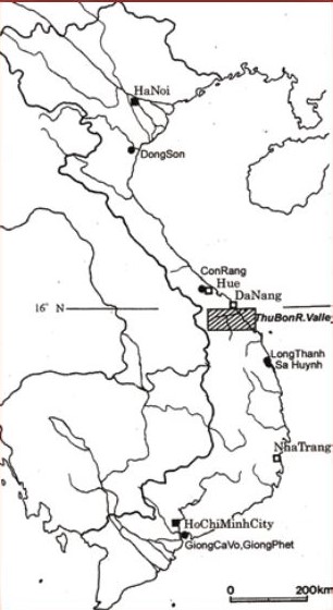
Map of Vietnam locating the Thu Bon River Valley. Image extracted from Yamagata Mariko. (2006). “Inland Sa Huynh Culture along the Thu Bon River valley in Central Vietnam”, p. 169. Edited by Elisabeth Bacus, Ian Glover & Vincent Pigott. Singapore: NUS Press. All rights reserved, NUS Press, 2006.
Central Vietnam is regarded by historians as a site of cultural interactions between the uplands and lowlands, and between north and south. According to Bennet Bronson’s ‘upstream-downstream exchange network’ model, the riverine exchange network system typically featured a coastal-based trade center, which was usually located at a river mouth as an entrepot port. There were also distant upstream or inland trading centers, which functioned as ‘feeder stations’ or initial concentration points for products originating from more remote parts of the river watershed. People living in upland or upriver villages produced and transported these forest products to the river mouth trading center, where they found a larger population through which they could tap into ‘a more productive and technologically advanced economy’.
Bronson’s model has been applied by scholars studying the history of early states in Peninsular Malaysia and Sumatra, as well as Champa, an ancient Hindu kingdom in central Vietnam. This model corresponds equally well with the geographical conditions of central Vietnam, where Champa was located historically. In this region, most of the rivers flowed from west to east, and from the high mountains and plateaus to the coast. Along each of the upland rivers were many villages inhabited by ethnic minorities. These upland peoples were connected via these rivers to the coastal trading centers that were located at the river mouths. Archaeological findings indicate that riverine-based upland-lowland exchanges have been practiced since prehistoric times.
Recent Archaeological Findings (from the 5th century BCE to the 2nd century CE) Offer New Explanations of the Upland-Lowland Exchange Network in Prehistoric Central Vietnam
Since the 1990s, new archaeological findings uncovered by Vietnamese and international archaeologists in excavations in Central Vietnam, particularly in the Thu Bon river basin in Quang Nam province since the 1990s, have provided us with a more comprehensive understanding of this land’s past, as well as insights into the interactions between upland and lowland areas during the prehistoric period.
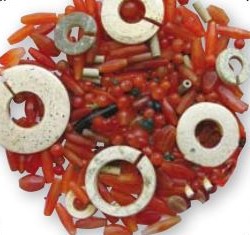
The Indian agates and beads of the prehistoric Sa Huynh culture found in Quang Nam province. Courtesy of Dr Lam My Dzung.
The archaeological artifacts found in central Vietnam indicate two foreign cultural influences, namely those of the Chinese Han Dynasty (206BCE–220CE) and the Indians. These finds prove the existence of a maritime trade relationship between a number of port cities and polities in central Vietnam, their counterparts in China and the Indian sub-continent. Central Vietnam played an important role in the ‘Maritime Silk Road’ from 500BCE to 300CE, thanks to the rich resources of its forests, as well as to its favourable geographical location, which offered a number of potential sites for useful entrepots.
The Sa Huynh Culture Along the Thu Bon River <sup>2</sup>
A great number of Sa Huynh burial sites have been uncovered along both banks of the Thu Bon river, from its tributaries all the way down to its lower reaches. In 1985, Vietnamese archaeologists excavated a burial ground of the Sa Huynh culture in Tabhing village, which is situated well inland in Quang Nam Province, along a stream that flows into Ben Giang (or Giang Wharf), an important exchange place in this area. Tabhing village is the home of the Katu people, an ethnic minority group that speaks a Mon-Khmer language in the Truong Son Range. Since 1997, Vietnamese archaeologists have collaborated with Japanese archaeologists to conduct excavations focusing on the Sa Huynh sites in the inland mountainous area, along the middle and upper reaches of the Thu Bon River.
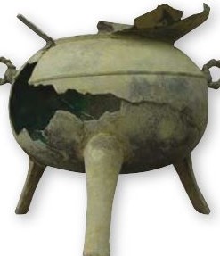
The Chinese bronze vessels of the prehistoric Sa Huynh culture found in the lowlands of Quang Nam province. Courtesy of Dr Lam My Dzung.
The archaeological sites found in both the coastal plains and the inland areas of the Thu Bon river basin display the same two cultural phases: an early phase and a later phase. The archaeological cultural material found in both the upstream and downstream areas appeared simultaneously and evolved continuously from the early phase to the late phase, and provide tangible evidence of the interactions between upland and lowland areas during the prehistoric period.
Sa Huynh Culture and International Trade
Historical documents in China provide evidence for the export of aromatic woods from central Vietnam to China. According to Chinese court records from the 3rd century CE, such as the Nanzhouyiwuzhi (“The Records of Strange Products of Southern Prefectures”), aloes-wood (or eaglewood) was produced in Rinan Prefecture (what is now considered central Vietnam), where local people collected it from the forests.
Most of the archaeologists who work in central Vietnam have agreed that it is possible to prove the existence of an international relationship between the Sa Huynh culture, India, and China, that took place in the following stages: firstly, from the 5th century BCE to the 2nd century CE, central Vietnam (the Thu Bon river basin) was a meeting ground between two cultural currents, i.e. Chinese influences from the North and Indian influences from the South. The number and kinds of imported items indicated that the Chinese influences from the North was stronger than the Indian influences from the South. Secondly, during the later period, from the 2nd to the 5th century CE, India and China both had equal influence upon central Vietnam. However, the Indian influence became more dominant in the region from the 5th century CE onwards. The cultural space of the Sa Huynh archaeological sites in Central Vietnam, from the coastal region up to the mountainous area, exactly overlapped those of the Champa kingdom(s) or polities that emerged during the successive centuries.
Thu Bon – The Longest of the Main Rivers in Central Vietnam
Thu Bon River in Quang Nam province is the longest of the main rivers in central Vietnam. The average amount of rainfall in this area is approximately 4,000 mm per year. Thanks to this huge amount of rain, the Thu Bon River is full of water all year round. This is the main stream connecting the mountainous and coastal areas, and it has played an important role in the exchange of goods between the uplands and the lowlands. Since the 5th century CE, the river was worshipped by the Cham dynasties as a holy river named Mahanadi (Great River) or Goddess Ganga, the consort of God Siva.
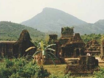
The Thu Bon River (Mahanadi or Ganga Holy River) with the My Son Mountain (Mahaparvata or Siva Holy Mountain) in the background.
The Thu Bon basin is the meeting place of all the main streams in Quang Nam province. Several prosperous markets along the Thu Bon River have served as collecting places for the forest products headed for the port city of Hoi An.
Along the upper reaches of Thu Bon River is the junction between the mountainous area and the midland at Hon Kem-Da Dung Wharf of the Thach Bich community, where a 7th century Cham stele was found. The inscription stated that the stele belonged to King Prakasadharma of the 7th century CE, “Sri Prakasadharma, king of Campa always victorious, master of the land, … has installed here the god Amaresa (Siva)”.3 This Cham inscription is the best evidence available that this area was previously ruled by Cham kings. In the Thach Bich community, a prehistoric archaeological site was also uncovered in August 2001. Thus, we can conclude that the ‘upland-lowland exchange network’ was already established by the Cham people (the urang Campa) as early as the 7th century, or even before the Champa period.
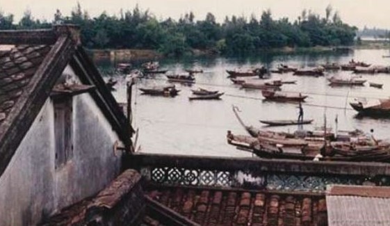
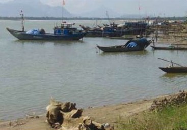
Life in the ancient Hoi An port-city is still closely associated with water.
Several Cham artifacts have been found in the famous riverine markets of the Thu Bon basin, providing evidence that all of these places were related to past Champa historical sites. Therefore, we might also argue that the patterns of interaction between lowlands and uplands in this region were already established in ancient times in order to collect forest products for export, even before the heyday of the port city of Hoi An in the 17th and 18th centuries. Then, it was known as “the nexus of a far-flung network of commerce and trade, making it one of the most important export and transhipment markets in the South China Sea”.4
The ‘Upland And Lowland Exchange Network’ During the Champa Period (from the 2nd to the 15th centuries CE)
The economy of the Champa kingdom(s) or polities,5 beyond its agricultural and fishing base, was largely centred on the coastal trade with India, China and the other lands of Southeast Asia. Champa was the closest source from which China could import many luxury goods, such as ivory, rhinoceros horns, cinnamon, aromatic woods and spices, while port-entrepots located along the coast provided useful shelter, fresh water and firewood for ships travelling along the coast from South Asia to East Asia. Thus, the Champa kingdom(s) provided some of the most significant middlemen in the South Sea or Nanhai trade.
The richness of the Cham sovereigns can be seen from religious architecture. Examples of such architecture can still be found in a large number of Hindu and Buddhist brick temple-towers in central Vietnam. The most remarkable of these temples are found in the Hindu complex of the My Son Sanctuary, including 68 temple-towers built from the end of the 4th to the 13th century CE. These have been included in the UNESCO World Cultural Heritage List since 1999. There is also the Dong Dzuong Monastery complex that was built in 875CE, now one of the most significant Buddhist historical architectural sites in Southeast Asia.
My Son Sanctuary, the largest Hindu temple of Champa kingdom built from the 4th to 13th century CE.
The inhabitants of the Champa kingdom(s) (known as the urang Campa), were considered by historians to have been very accomplished merchants. Based along the main rivers in the region, they established an economic network for exchanging goods between the upland and lowland areas. These merchants handled the exchange of commodities between the coastal people and the inland people of the mountainous areas.
The Katu People as the Uplanders
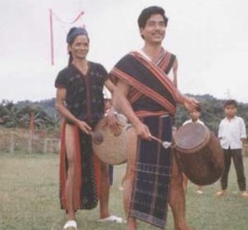
The colourful traditional culture of the Katu people in the uplands of central Vietnam.
Quang Nam province’s mountainous area is the homeland of the Katu people, who are Mon-Khmer speakers. The Katu population of Vietnam, which now numbers about 25,000, have treasured and sustained their own ancient traditional culture very well. The majority of the Katu people are living mostly in the Sekong province of Laos PDR, along the border with Vietnam. They still retain “a wealth of interesting customs, traditions, knowledge and folklore about astrology, medicine and other sciences”.6
The scattered villages of the Katu people in Quang Nam province were built from the upper reaches all the way down to the lower reaches of the main rivers in this area. Nowadays, the Katu people who live closest to the lowland are concentrated at Phu Tuc hamlet, west of Danang City, about 15km from the seashore. The Katu people also call themselves ‘Phuong’, meaning ‘people living in the upper land in the jungle’.
Salt is the most important item of trade between lowlanders and uplanders. Salt was emphasized in most of the studies of uplanders. They even built a main trading route called ‘the road of salt’. In the mid-20th century, the French ethnologist, Jacques Dournes (Dam Bo), succinctly described this ‘great road’ from the highland to the coast in his monograph on the ethnic people in the highland of central Vietnam.7 The Salt Road connected uplands and lowlands and brought people together, not only for the exchange of commodities, but for cultural and intermarriage reasons as well. Even now, local Kinh people in the lowlands and Katu people living in the uplands still carry out the trade in salt within the Thu Bon basin.8
The trading of salt with lowlanders in the early 20th century was recorded in a Katu folksong:
“He is the master of salt,
We are always his friends,
Because he provides us with buffalos to eat,
And makes trading convenient,
We drink a cup of rice wine with him,
Our village communal house is his house,
Because he is strong and wealthy,
We want to make friends with him”.9
The ‘Upland-lowland Exchange Network’ in Central Vietnam: the Patterning of Multiethnic Coexistence in the Region
Because of its geographical location midway between North and South Vietnam, Quang Nam province is a melting pot of cultures. This accounts for the coexistence of Malayo-Polynesian speakers and Mon-Khmer speakers, as well as the Kinh people or Vietnamese speakers among the former local people. During the pre-Vietnamese period, in the 16th century, people in the Thu Bon basin spoke their own Cham language and maintained the old customs of the Cham. These lowlanders may have started speaking Vietnamese sometime during the 17th century. Linguistic mixture is clearly reflected in the unique dialect of the Vietnamese speakers who live in the Thu Bon basin.
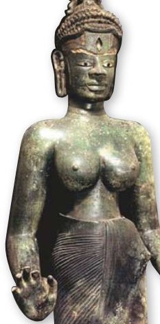
The Cham Buddhist bronze statue of LaksmindraLokesvara made at the end of the 9th century.
The cultural elements of the Champa Kingdom(s) still persist in central Vietnam. The Cham cultural influences were still very strong in the 16th and 17th centuries, when this region was called Ke Chiem or Xu Chiem, meaning the ‘Territory of Champa’, according to most of the accounts written by Westerners and Japanese who came to central Vietnam or Cochin-China at that time. Historical and linguistic evidence clearly indicate that a pattern of coexistence had long characterised the interactions among the people in the Thu Bon basin in particular, as well as in central Vietnam as a whole.
Acknowledgements
The author wishes to acknowledge the contributions of Associate Professor Bruce Lockhart, Department of History, Faculty of Arts and Social Sciences, National University of Singapore in reviewing the paper.
About the Author
Tran Ky-Phuong is a Lee Kong Chian Research Fellow of the National Library Singapore.
Endnotes
1 Bennet Bronson, “Exchange at the Upstream and Downstream Ends: Notes Toward a Functional Model of the Coastal State in Southeast Asia,” in Economic Exchange and Social Interaction in Southeast Asia: Perspectives From Prehistory, History, and Ethnography, ed. Karl L. Hutterer (Ann Arbor: Center for South and Southeast Asian Studies, University of Michigan, 1977), 39–54. (Call no. RSING 382.0959 ECO)
2 The Sa Huynh culture was an Iron Age culture belonging to a period between 500BCE and 100CE. Most of its sites were found in central Vietnam through the archaeological excavations carried out since the beginning of the last century up to the present time. Sa Huynh is a small village on the coast of Quang Ngai province in central Vietnam nowadays, where the first excavation of this culture was conducted in the early twentieth century by French archaeologists.
3 Karl-Heinz Golzio, ed., Inscriptions of Campa (Aachen: Shaker Verlag, 2004), 5.
4 Charles James Wheeler, “Re-Thinking the Sea in Vietnamese History: Littoral Society in the Integration of Thuan-Quang, Seventeenth-Eighteenth Centuries,” Journal of Southeast Asian Studies 37, no. 1 (February 2006): 134. (From JSTOR via NLB’s eResources website)
5 The Champa kingdom(s) of Vietnam is dated from late 2nd century CE. Its territories ranged from south of the Ngang pass in Quång Bình province to Bình Thuân province (approximately between latitudes 11° N and 18° N) in south-central Vietnam. According to Chinese historical documents, in 192–193CE due to the harsh rule of the Han Dynasty (206BCE–220CE), the people of Tòng Lâm district (Xiang Lin) revolted, killed the local Chinese mandarin official, gained their sovereignty and established their own independent state. It was first named Lâm Âp (Lin-yi) (192–758), later known as Hoàn Vòng (Huan-Wang) (758–886), and then Chiêm Thành (Zhan Cheng) (886–1471). The name Chiêm Thành (Zhan Cheng) comes from Champapura in Sanskrit, the city of Champa. The Champa kingdom(s) was basically located on a strip of land that was more than a thousand kilometers along the coast of central Vietnam. Recently, historians have argued that Champa kingdom was a composition of several independent states/polities, which indicates that the kingdom was not one unified political entity, but a federation of several regions which had their own political centers. In 1471, the capital city of the kingdom(s) known as Vijaya (in Binh Dinh Province today) was captured by the Vietnamese. A small Cham kingdom survived under Vietnamese influence, though its territory continued to shrink. In the 19th century, the last remnant of Champa was formally absorbed by Vietnam. See Bruce M. Lockhart and William J. Duiker, Historical Dictionary of Vietnam (Lanham: The Scarecrow Press, 2006), 65–66. (Call no. RSEA 959.7003 LOC)
6 Nancy Costello, “Katu Society: A Harmonious Way of Life,” in Laos and Ethnic Minority Cultures: Promoting Heritage, ed. Yves Goudineau (Paris: UNESCO, 2003), 163. (Call no. RSEA q305.89594 LAO)
7 Dam Bo, Les Populations Montagnardes Du Sud-Indochnois (Lyon: Derain, 1950), 3–47. (Call no. RSEA 950.05 FA)
8 Quach Xan, “Giac Mua” [Seasonal enemy], in Ngoc Linh, Chuyen De Nghien Cuu, Sang Tac Ve Mien Nui & Tay Nguyen [Ngoc Linh Magazine, Special Researches and Literary Works on Mountainous Area and Central Vietnam Highland no. 1 (2000): 71–106.
9Jean Le Pichon, Les Chassuers De Sang, Bulletin des Amis du Vieux Hue, 4 (1938): 364.
References
Anthony Reid, Charting the Shape of Early Modern Southeast Asia (Singapore: Institute of Southeast Asian Studies, 2000). (Call no. R 959 REI)
Bennet Bronson, “Exchange at the Upstream and Downstream Ends: Notes Toward a Functional Model of the Coastal State in Southeast Asia,” in Economic Exchange and Social Interaction in Southeast Asia: Perspectives From Prehistory, History, and Ethnography, ed. Karl L. Hutterer (Ann Arbor: Center for South and Southeast Asian Studies, University of Michigan, 1977), 39–54. (Call no. RSING 382.0959 ECO n.13)
Bruce M. Lockhart and William J. Duiker, Historical Dictionary of Vietnam (Lanham: The Scarecrow Press, 2006). (Call no. RSEA 959.7003 LOC)
Charles James Wheeler, “Re-Thinking the Sea in Vietnamese History: Littoral Society in the Integration of Thuan-Quang, Seventeenth-Eighteenth Centuries,” Journal of Southeast Asian Studies 37, no. 1 (February 2006): 123–52. (From JSTOR via NLB’s eResources website)
Charles James Wheeler, “One Region, Two Histories: Cham Precedents in the History of the Hoi an Region,” in Viet Nam: Borderless Histories, ed. Nhung Tuyet Tran and Anthony J. S. Reid (Madison: University of Wisconsin Press, 2006), 163–93. (Call no. RSEA 959.7 VIE)
D. A. Dao, “Su Thanh Lap Nuoc Lam Ap” [The formation of Lam Ap state], in History of Viet Nam From the Original to the XIX Century, vol. 1 (Hanoi: Van Hoa Publishing House, 1957)
Dam Bo, Les Populations Montagnardes Du Sud-Indochnois (Lyon: Derain, 1950). (Call no. RSEA 950.05 FA)
Duong Van An, O Chau Can Luc [The accounts of O Chau prefecture] (Hue: Thuan Hoa Publishers, 2001)
Gerald Cannon Hickey, Sons of the Mountains: Ethnohistory of the Vietnamese Central Highlands to 1954 (New Haven: Yale University Press, 1982). (Call no. RSEA 959.7004999 HIC)
H. T. Nguyen, ed., Tin Nguong Tho Mau O Mien Trung Viet Nam [The cults involving worship of the Holy Mothers in Central Vietnam]. (Hue: Thuan Hoa Publisher, 2001)
Jan Wisseman, “Trade and State Formation in the Malay Peninsula and Sumatra, 300BC–AD700,” in The Southeast Asian Port and Polity: Rise and Demise, ed. J. Kathirithamby-Wells and John Villiers (Singapore: Singapore University Press, 1990), 39–60. (Call no. RSING 387.10959 SOU)
Jean Le Pichon, Les Chassuers De Sang, Bulletin des Amis du Vieux Hue, 4 (1938): 357–409.
K. P. Tran, “GOP Phan Tim Hieu Ve Nen Van Minh Cua Vuong Quoc Co Champa Tai Mien Trung Viet Nam” [A contribution to the comprehension on the civilization of the ancient Champa Kingdom in Central Vietnam], Nghien cuu & Phat trine [Journal of Research and Development] 3, no. 37 and 4, no. 38 (2002): 63–74 and 71–78.
K. P. Tran, “Buoc Dau Tim Hieu Ve Dia-L Ch Su Cua Vuong Quoc Chiem Thanh (Champa) O Mien Trung Viet Nam: Voi Su Tham Chieu Dac Biet Vao ‘He Thong Trao Doi Ven Song’ Cua Luu Vuc Song Thu Bon O Quang Nam” [Preliminary research on the historical geography of the Champa kingdom in Central Vietnam: in regard to ‘riverine exchange network’ of the basin of Thu Bon river in Quang Nam Province], Thong tin Khoa hoc, Thang [Scientific Reports] 3 (2004)
Lam Thi My Dzung, “Regional and Inter-Regional Interactions in the Context of Sa Huynh Culture: With Regards to the Thu Bon Valley in Quang Nam Province, Vietnam” (Paper presented at the 18th International Congress of Indo-Pacific Prehistory Association, University of Philippines, Manila, March 2006)
Le Quy Don, Phu Bien Tap Luc, Le Quy Don Toan Tap, tap 1 [Desultory notes from the frontier, completed works of Le Quy Don, vol. 1] (Hanoi: Nha Xuat Ban Khoa Hoc Xa Hoi, 1977)
Leonard Y. Andaya, Leaves of the Same Tree: Trade and Ethnicity in the Straits of Melaka (Honolulu: University of Hawai Press, 2008). (Call no. RSEA 305.80095951 AND)
Li Tana, Nguyen Cochinchina: Southern Vietnam in the Seventeenth and Eighteenth Centuries (Ithaca, NY.: Southeast Asia Program, Cornell University, 1998). (Call no. RSEA q959.703 LI)
Mariko Yamagata, “Tra Kieu of the Second and the Third Centuries A.D.: The Formation of Linyi (Champa) From the Archaeological Point of View” (Asia Research Institute paper presented at a symposium on new scholarship on Champa, National University of Singapore, August 2004)
Mariko Yamagata, M. (2006). “Inland Sa Huynh Culture Along the Thu Bon River Valley in Central Vietnam,” in Uncovering Southeast Asia’s Past, ed. Elisabeth A. Bacus, Ian C. Glover and Vincent C. Pigott (Singapore: NUS Press, 2006), 168–83. (Call no. RSING 959.01 EUR)
Nancy Costello, “Katu Society: A Harmonious Way of Life,” in Laos and Ethnic Minority Cultures: Promoting Heritage, ed. Yves Goudineau (Paris: UNESCO, 2003), 163–76. (Call no. RSEA q305.89594 LAO)
Olga Dror and K.W. Taylor, eds., Views of Seventeenth–Century Vietnam: Christoforo Borri on Cochinchina & Samuel Baron on Tonkin (Ithaca: Southeast Asia Program Publications, Southeast Asia Program, Cornell University, 2006). (Call no. RSEA 959.703 VIE)
Oscar Salemink, The Ethnography of Vietnam’s Central Highlanders: A Historical Contextualization, 1850–1990 (London: RoutledgeCurzon, 2003). (Call no. RSEA 306.0899593 SAL)
Peter Bellwood, Prehistory of the Indo-Malaysian Archipelago (Honolulu: University of Hawai’i Press, 1997). (Call no. RSEA 959.01 BEL)
Philip Taylor, Goddess on the Rise: Pilgrimage and Popular Religion in Vietnam (Honolulu: University of Hawaii Press, 2004). (Call no. RSEA 299.592 TAY)
Pierres-Yves Manguin, “The Amorphous Nature of Coastal Polities in Insular Southeast Asia: Restricted Centres, Extended Peripheries,” Moussons 5 (2002): 73–99.
Quach Xan, “Giac Mua” [Seasonal enemy], Ngoc Linh, chuyen de nghien cuu, sang tac ve Mien Nui & Tay Nguyen [Ngoc Linh Magazine, Special Researches and Literary Works on Mountainous Area and Central Vietnam Highland] 1 (2000): 71–106.
Rie Nakamura, Cham in Vietnam: Dynamics of Ethnicity (Washington: University of Washington, 1999)
Thinh T. Doan, “Ho An Dialect,” in National Committee for the International symposium on the Ancient Town of Hoi An, Ancient Town of Hoi An: [international symposium held in Danang on 22–23 March 1990] (Hanoi: The Gioi Publishers, 2006), 139–48. (Call no. RSEA 959.703 ANC)
Tr’an Ky Phương, Vestiges of Champa Civilization (Hanoi: The Gioi Publishers, 2004). (Call no. RSEA 959.703 TRA)
Wang Gungwu, The Nanhai Trade: Early Chinese Trade in the South China Sea (Singapore: Eastern University Press, 2003). (Call no. RBUS 382.0951059 WAN)
William A. Southworth, “River Settlement and Coastal Trade: Towards a Specific Model of Early State Development in Champa” (Asia Research Institute paper presented at a symposium on new scholarship on Champa, National University of Singapore, August 2004)
William A. Southworth, “The Coastal States of Champa,” in Southeast Asia: From Prehistory to History, ed. Ian Glover and Peter Bellwood (New York: RoutledgeCurzon, 2004), 209–33. (Call no. RSEA 959 SOU)